Ettringen (Nadrenia-Palatynat)
| gmina | |||
 | |||
| |||
| Państwo | |||
|---|---|---|---|
| Kraj związkowy | |||
| Powiat | Mayen-Koblenz | ||
| Wspólnota | Gmina związkowa Vordereifel | ||
| Powierzchnia | 9,16 km² | ||
| Wysokość | 400 m n.p.m. | ||
| Populacja (31 grudnia 2009) • liczba ludności | 2 744 | ||
| • gęstość | 300 os./km² | ||
| Numer kierunkowy | 02651 | ||
| Kod pocztowy | 56729 | ||
| Tablice rejestracyjne | MYK, MY | ||
Adres urzędu: Kelberger Straße 2656727 Mayen | |||
Położenie na mapie powiatu | |||
| 50°22′N 7°13′E/50,366667 7,216667 | |||
| Strona internetowa | |||
| Portal | |||
Ettringen – miejscowość i gmina w Niemczech, w kraju związkowym Nadrenia-Palatynat, w powiecie Mayen-Koblenz, wchodzi w skład gminy związkowej Vordereifel.
Bibliografia
- Statistisches Landesamt Rheinland-Pfalz, Bad Ems
Media użyte na tej stronie
Flag of Rhineland-Palatinate.svg
Civil and state flag of the state Rhineland-Palatinate
Civil and state flag of the state Rhineland-Palatinate
Ettringen Mayen-Koblenz SSO.JPG
Autor: Rs-foto, Licencja: CC BY-SA 4.0
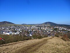
Ettringen (district Mayen-Koblenz, Rhineland-Palatinate, Germany) from SSE, view fromout the Ettringer Bellerberg
Autor: Rs-foto, Licencja: CC BY-SA 4.0
Ettringen (district Mayen-Koblenz, Rhineland-Palatinate, Germany) from SSE, view fromout the Ettringer Bellerberg
Wappen der Ortsgemeinde Ettringen.png
Wappen der Ortsgemeinde Ettringen (Eifel)
Wappen der Ortsgemeinde Ettringen (Eifel)
Ettringen in MYK.png
Autor: Rauenstein, Licencja: CC BY-SA 3.0
Ettringen in Rhineland-Palatinate - district Mayen-Koblenz
Autor: Rauenstein, Licencja: CC BY-SA 3.0
Ettringen in Rhineland-Palatinate - district Mayen-Koblenz


