Euston Square
 | |
| Państwo | |
|---|---|
| Miejscowość | |
| Dzielnica | Euston Road |
| Data otwarcia | 1863 |
| Liczba peronów | 2 |
| Circle Line | |
| Poprzednia stacja | |
| Następna stacja | |
| Hammersmith & City Line | |
| Poprzednia stacja | |
| Następna stacja | |
| Metropolitan Line | |
| Poprzednia stacja | |
| Następna stacja | |
Położenie na mapie gminy Camden  Contains Ordnance Survey data © Crown copyright and database right, CC BY-SA 3.0 | |
Położenie na mapie Wielkiej Brytanii  (c) Karte: NordNordWest, Lizenz: Creative Commons by-sa-3.0 de | |
Położenie na mapie Anglii  | |
Położenie na mapie Wielkiego Londynu  Contains Ordnance Survey data © Crown copyright and database right, CC BY-SA 3.0 | |
| Portal | |
Euston Square – stacja londyńskiego metra położona przy skrzyżowaniu ulic Euston Road i Gower Street w gminie Camden, w pierwszej strefie biletowej. Znajduje się pomiędzy stacjami Great Portland Street i King’s Cross St. Pancras, na trasach linii Circle, Metropolitan i Hammersmith & City[1].
W 2011 roku ze stacji skorzystało 10,89 miliona pasażerów[2].
Stacja została otwarta 10 stycznia 1863 roku pod nazwą Gower Street na pierwszym odcinku metra na świecie, będącym częścią Metropolitan Railway (stacja obsługiwała linię do 1932 roku). 1 listopada 1909 roku nazwa stacji została zmieniona na Euston Square[3].
13 grudnia 2006 roku przedstawiciele Network Rail ogłosili plan rozbudowy stacji kolejowej Euston Station, który miał obejmować m.in. połączenie obu stacji przejściem podziemnym[4].
Galeria

Platforma w kierunku zachodnim
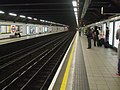
Platforma w kierunku wschodnim
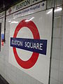
Symbol stacji
Przypisy
- ↑ Schemat sieci metra w Londynie (ang.). Transport for London. [dostęp 2012-05-23]. [zarchiwizowane z tego adresu (2008-06-26)].
- ↑ Customer metrics: entries and exits (ang.). Transport For London. [dostęp 2012-05-23].
- ↑ Euston Square (ang.). London Moving. [dostęp 2012-05-23]. [zarchiwizowane z tego adresu (2013-01-30)].
- ↑ Euston redevelopment (ang.). alwaystouchout.com. [dostęp 2012-05-23].
Linki zewnętrzne
- Profil stacji Euston Square na stronie Transport for London
| Pętla |
|
|---|---|
| Odgałęzienie Hammersmith |
|
![]()
|
![]()
| Linia główna |
|
|---|---|
| Odgałęzienie Uxbridge |
|
| Odgałęzienie Northwood |
|
| Odgałęzienie Watford |
|
| Odgałęzienie Chesham / Amersham |
|
![]()
Media użyte na tej stronie
(c) Karte: NordNordWest, Lizenz: Creative Commons by-sa-3.0 de
Location map of the United Kingdom
Contains Ordnance Survey data © Crown copyright and database right, CC BY-SA 3.0
Map of Greater London, UK with the following information shown:
- Administrative borders
- Coastline, lakes and rivers
- Roads and railways
- Urban areas
The data includes both primary routes and railway lines.
Equirectangular map projection on WGS 84 datum, with N/S stretched 160%
Geographic limits:
- West: 0.57W
- East: 0.37E
- North: 51.72N
- South: 51.25N

Contains Ordnance Survey data © Crown copyright and database right, CC BY-SA 3.0
Blank map of the London Borough of Camden, showing electoral wards.
Equirectangular map projection on WGS 84 datum, with N/S stretched 160%
Geographic limits:
- West: 0.22W
- East: 0.10W
- North: 51.58N
- South: 51.51N

Autor: Sunil060902, Licencja: CC BY-SA 3.0
Euston Square tube station platform roundel, indicating proximity to University College Hospital.


Autor: Sunil060902, Licencja: CC BY-SA 3.0
Euston Square tube station platforms looking east.

Autor: Sunil060902, Licencja: CC BY-SA 3.0
Euston Square tube station northern entrance, on Euston Road

Autor: Sunil060902, Licencja: CC BY-SA 3.0
Euston Square tube station platforms looking west
