Evansville (Indiana)
 | |||
| |||
| Państwo | |||
|---|---|---|---|
| Stan | |||
| Hrabstwo | |||
| Data założenia | 1812[1] | ||
| Prawa miejskie | 1819[1] | ||
| Burmistrz | Lloyd Winnecke | ||
| Powierzchnia | 105,6 km² | ||
| Wysokość | 118 m n.p.m. | ||
| Populacja (2018) • liczba ludności • gęstość |
| ||
| Nr kierunkowy | 812 | ||
| Kod pocztowy | 47708 | ||
| Strefa czasowa | |||
Położenie na mapie Indiany  | |||
Położenie na mapie Stanów Zjednoczonych  | |||
| Strona internetowa | |||
| Portal | |||
Evansville – miasto w Stanach Zjednoczonych, w stanie Indiana, nad rzeką Ohio. Okręg miejski ma około 121,500 mieszkańców, a okręg metropolitalny 342,815, a Evansville jest trzecim co do wielkości miastem w Południowej Indiana. Jest siedzibą hrabstwa Vanderburgh leżącego na styku trzech stanów: Indiana, Kentucky i Illinois.
Evansville założono w 1812 roku w zakolu rzeki Ohio, w związku z czym nosi przydomek "River City." Miasto jest siedzibą University of Evansville oraz University of Southern Indiana.
Gospodarka
W mieście rozwinął się przemysł maszynowy, elektrotechniczny, chemiczny oraz hutniczy[1].
Demografia
Sport
W mieście rozgrywany jest kobiecy turniej tenisowy, pod nazwą The Women's Hospital Classic, zaliczany do rangi ITF, z pulą nagród 15 000 $.[4]
Urodzeni w Evansville
- Luke Messer, amerykański polityk, kongresman ze stanu Indiana
Galeria

University of Evansvile
 (c) Randella, CC-BY-SA-3.0
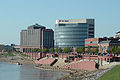
Centrum miasta Evansville, budynki nad rzeką Ohio.
Miasta partnerskie
 Osnabrück
 Tochigi-Shi
Przypisy
- ↑ a b c Evansville, [w:] Encyklopedia PWN [online] [dostęp 2021-06-27].
- ↑ Population and Housing Unit Estimates. [zarchiwizowane z tego adresu]. (ang.).
- ↑ Census of Population and Housing. Census.gov. [zarchiwizowane z tego adresu]. (ang.).
- ↑ Evansville Tennis Center – Where Players Become Champions [zarchiwizowane z adresu 2017-12-11].
Media użyte na tej stronie
Autor: Uwe Dedering, Licencja: CC BY-SA 3.0
Location map of the USA (without Hawaii and Alaska).
EquiDistantConicProjection:
Central parallel:
* N: 37.0° N
Central meridian:
* E: 96.0° W
Standard parallels:
* 1: 32.0° N
* 2: 42.0° N
Made with Natural Earth. Free vector and raster map data @ naturalearthdata.com.
Formulas for x and y:
x = 50.0 + 124.03149777329222 * ((1.9694462586094064-({{{2}}}* pi / 180))
      * sin(0.6010514667026994 * ({{{3}}} + 96) * pi / 180))
y = 50.0 + 1.6155950752393982 * 124.03149777329222 * 0.02613325650382181
      - 1.6155950752393982  * 124.03149777329222 *
     (1.3236744353715044  - (1.9694462586094064-({{{2}}}* pi / 180))
      * cos(0.6010514667026994 * ({{{3}}} + 96) * pi / 180))

The flag of Navassa Island is simply the United States flag. It does not have a "local" flag or "unofficial" flag; it is an uninhabited island. The version with a profile view was based on Flags of the World and as a fictional design has no status warranting a place on any Wiki. It was made up by a random person with no connection to the island, it has never flown on the island, and it has never received any sort of recognition or validation by any authority. The person quoted on that page has no authority to bestow a flag, "unofficial" or otherwise, on the island.


(c) Randella, CC-BY-SA-3.0
Original photograph with free documentation license.

Flag of Evansville, IN (based from http://www.crwflags.com/fotw/flags/us-ineva.html#des and http://blogs.courierpress.com/whicker/DSC02790.JPG)

Autor: Alexrk2, Licencja: CC BY 3.0
Ta mapa została stworzona za pomocą GeoTools.
Autor: Vasiliymeshko, Licencja: CC BY-SA 4.0
Panorama of downtown Evansville from Dreier Blvd