Exeter St Davids
 | |
| Państwo | |
|---|---|
| Kraj | |
| Miejscowość | |
| Zarządca | |
| Data otwarcia | 1844 |
| Dane techniczne | |
| Liczba peronów | 4 |
| Liczba krawędzi peronowych | 8 |
| Kasy | czynne |
| Linie kolejowe | |
Schemat stacji | |
Położenie na mapie Exeteru Contains Ordnance Survey data © Crown copyright and database right, CC BY-SA 3.0 | |
Położenie na mapie Wielkiej Brytanii (c) Karte: NordNordWest, Lizenz: Creative Commons by-sa-3.0 de | |
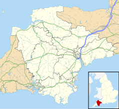
Położenie na mapie Devonu Contains Ordnance Survey data © Crown copyright and database right, CC BY-SA 3.0 | |
| Portal | |
Exeter St. Davids – węzłowa stacja kolejowa w mieście Exeter, w hrabstwie Devon, o znaczeniu regionalnym i ogólnokrajowym. Jest największą stacją kolejową w mieście. Budynek dworca zaprojektował XIX-wieczny inżynier i architekt brytyjski Isambard Kingdom Brunel, początkowo jako stację czołową. Do ogólnobrytyjskiej sieci kolei włączona w roku 1876. Stacja bez sieci trakcyjnej.
Ruch pasażerski
Stacja Exeter St Davids obsługuje 727 776 pasażerów rocznie (dane za okres od kwietnia 2020 do marca 2021)[1], co daje jej pierwszą pozycję wśród wszystkich stacji kolejowych południowego zachodu Anglii. Posiada bezpośrednie połączenia z następującymi większymi miejscowościami: Barnstaple, Birmingham, Bristol. Glasgow, Leeds, Liverpool, Londyn, Penzance, Plymouth, Southampton. Obsługuje również lokalną linię do Exmouth.
Linie kolejowe wychodzące z Exeter St Davids
- Linia kolejowa Bristol – Exeter
- Linia kolejowa Exeter – Plymouth
- Riviera Line
- Tarka Line
- Avocet Line
- West of England Main Line
Obsługa pasażerów
Kasy biletowe, automaty biletowe, wózki peronowe, windy peronowe, kiosk, WC, bar, księgarnia, poczekalnia, przystanek autobusowy, postój taksówek.
Przypisy
- ↑ Estimates of station usage. Table 1410: Passenger entries, exits and interchanges by station (annual), Great Britain, Apr 2020 to Mar 2021, Office of Rail and Road Data Portal [dostęp 2022-10-25] [zarchiwizowane z adresu 2022-10-18] (ang.).
Media użyte na tej stronie
(c) Karte: NordNordWest, Lizenz: Creative Commons by-sa-3.0 de
Location map of the United Kingdom
Flag of England. Saint George's cross (a red cross on a white background), used as the Flag of England, the Italian city of Genoa and various other places.
Autor: Geof Sheppard, Licencja: CC BY-SA 3.0
A diagram (not to scale) of the tracks and platforms at St Davids station, Exeter, Devon, England.
Contains Ordnance Survey data © Crown copyright and database right, CC BY-SA 3.0
Map of Devon, UK with the following information shown:
- Administrative borders
- Coastline, lakes and rivers
- Motorways and primary routes
- Urban areas
Equirectangular map projection on WGS 84 datum, with N/S stretched 150%
Geographic limits:
- West: 4.72W
- East: 2.86W
- North: 51.3N
- South: 50.16N
Contains Ordnance Survey data © Crown copyright and database right, CC BY-SA 3.0
Map of Exeter, Devon, UK with electoral wards as of 2016 shown.
Equirectangular map projection on WGS 84 datum, with N/S stretched 150%
Geographic limits:
- West: 3.58W
- East: 3.45W
- North: 50.77N
- South: 50.66N
Autor: Geof Sheppard, Licencja: CC BY-SA 4.0
The front of St Davids railway station, Exeter, Devon, England.


