Fairlop
 (c) Sunil060902, CC-BY-SA-3.0 Budynek stacji Fairlop, 2007 | |
| Państwo | |
|---|---|
| Miejscowość | Londyn |
| Data otwarcia | 1948 |
| Liczba peronów | 2 |
| Central Line | |
| Poprzednia stacja | Barkingside |
| Następna stacja | Hainault |
Położenie na mapie gminy Redbridge  Contains Ordnance Survey data © Crown copyright and database right, CC BY-SA 3.0 | |
Położenie na mapie Wielkiej Brytanii  (c) Karte: NordNordWest, Lizenz: Creative Commons by-sa-3.0 de | |
Położenie na mapie Anglii  | |
Położenie na mapie Wielkiego Londynu  Contains Ordnance Survey data © Crown copyright and database right, CC BY-SA 3.0 | |
| Portal | |
Fairlop – stacja londyńskiego metra położona w zachodniej części miasta, na trasie Central Line pomiędzy stacjami Barkingside a Hainault. Znajduje się w dzielnicy Fairlop w gminie London Borough of Redbridge, w czwartej strefie biletowej[1].
Galeria
 (c) Sunil060902, CC-BY-SA-3.0
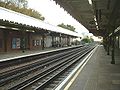
Widok na północ
 (c) Sunil060902, CC-BY-SA-3.0
Widok na południe

Symbol stacji
Przypisy
- ↑ Tube stations - Fairlop (ang.). Transport For London. [dostęp 2012-01-10].
| Linia główna | |
|---|---|
| Odgałęzienie West Ruislip | |
| Odgałęzienie Ealing Broadway | |
| Odgałęzienie Woodford | |
| Odgałęzienie Epping |
![]()
Media użyte na tej stronie
United Kingdom adm location map.svg
(c) Karte: NordNordWest, Lizenz: Creative Commons by-sa-3.0 de
Location map of the United Kingdom
(c) Karte: NordNordWest, Lizenz: Creative Commons by-sa-3.0 de
Location map of the United Kingdom


Redbridge London UK blank ward map.svg
Contains Ordnance Survey data © Crown copyright and database right, CC BY-SA 3.0
Contains Ordnance Survey data © Crown copyright and database right, CC BY-SA 3.0
Blank map of the London Borough of Redbridge, showing electoral wards.
Equirectangular map projection on WGS 84 datum, with N/S stretched 160%
Geographic limits:
- West: 0
- East: 0.16E
- North: 51.635N
- South: 51.535N

Fairlop roundel.JPG
Autor: Sunil060902, Licencja: CC-BY-SA-3.0
Roundel above seating on Fairlop tube station eastbound platform
Autor: Sunil060902, Licencja: CC-BY-SA-3.0
Roundel above seating on Fairlop tube station eastbound platform

Fairlop south.JPG
(c) Sunil060902, CC-BY-SA-3.0
en:Fairlop tube station looking south. Sunil060902, 11th November 2007.
(c) Sunil060902, CC-BY-SA-3.0
en:Fairlop tube station looking south. Sunil060902, 11th November 2007.
Greater London UK location map 2.svg
Contains Ordnance Survey data © Crown copyright and database right, CC BY-SA 3.0
Contains Ordnance Survey data © Crown copyright and database right, CC BY-SA 3.0
Map of Greater London, UK with the following information shown:
- Administrative borders
- Coastline, lakes and rivers
- Roads and railways
- Urban areas
The data includes both primary routes and railway lines.
Equirectangular map projection on WGS 84 datum, with N/S stretched 160%
Geographic limits:
- West: 0.57W
- East: 0.37E
- North: 51.72N
- South: 51.25N
Fairlop stn building.JPG
(c) Sunil060902, CC-BY-SA-3.0
en:Fairlop tube station building, much as it was when first opened by the en:Great Eastern Railway in 1903. Sunil060902, 11th November 2007.
(c) Sunil060902, CC-BY-SA-3.0
en:Fairlop tube station building, much as it was when first opened by the en:Great Eastern Railway in 1903. Sunil060902, 11th November 2007.

Fairlop north.JPG
(c) Sunil060902, CC-BY-SA-3.0
en:Fairlop tube station looking north. Sunil060902, 11th November 2007.
(c) Sunil060902, CC-BY-SA-3.0
en:Fairlop tube station looking north. Sunil060902, 11th November 2007.