Fengtai
| Ten artykuł od 2012-01 wymaga zweryfikowania podanych informacji. |
| Dzielnica Pekinu | |
 | |
| Państwo | |
|---|---|
| Miasto | |
| Powierzchnia | 306 km² |
| Populacja (2000) • liczba ludności |
|
| • gęstość | 4444,4 os./km² |
| Strefa numeracyjna | 010 |
| Kod pocztowy | 100071 |
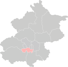
Położenie na mapie Pekinu | |
| 39°49′42″N 116°16′56″E/39,828333 116,282222 | |
| Strona internetowa | |
| Portal | |
Fengtai (chiń. upr. 丰台区, chiń. trad. 豐台區, pinyin: Fēngtái Qū) – dzielnica Pekinu położona na południowy zachód od centrum miasta.
Liczy 306 km² powierzchni i 1 360 000 mieszkańców (2000). Jej kod pocztowy to 100071.
Media użyte na tej stronie
Autor: User:Vmenkov, Licencja: CC-BY-SA-3.0
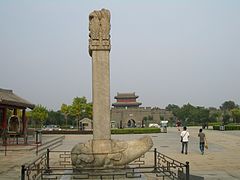
The stele commemorating Kangxi Emperor's rebuilding of the eastern part of the Lugou Bridge after it was damaged by flood. It stands on top of a bixi turtle, next to Qianlong's "Morning moon over the Lugou" stele, and is noticeably eroded. The sign by the stele says that it was put up in the 8th year of the Kangxi era (i.e. circa 1669), commemorating the rebuilding that took place in the 7th year of Kangxi era (i.e., ca. 1668). However, most sources only mention Kangxi's rebuilding that took plpace in 1698. The west gate of Wanping Castle is in the background.


