Finn (rzeka)
(c) Kay Atherton, CC BY-SA 2.0 Widok z mostu między Stranorlar i Ballybofey | |
| Kontynent | Europa |
|---|---|
| Państwo | |
| Rzeka | |
| Długość | 65 km |
| Powierzchnia zlewni | 500 km² |
| Źródło | |
| Miejsce | Lough Finn |
| Wysokość | 128 |
| Współrzędne | 54°52′15,5″N 8°06′14,9″W/54,870972 -8,104139 |
| Ujście | |
| Recypient | rzeka Foyle |
| Miejsce | Strabane |
| Współrzędne | 54°49′43,6″N 7°28′50,7″W/54,828778 -7,480750 |
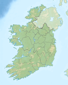
Finn (irl. Abhainn na Finne) – rzeka w Irlandii w hrabstwie Donegal i w Irlandii Północnej w hrabstwie Tyrone.
Finn wypływa z jeziora Finn w hrabstwie Donegal w Irlandii i górską doliną dopływa do Ballybofey, mija Killygordon, Castlefinn i na krótkim odcinku ok. 7 km między Clady i Strabane, gdzie wpływa do rzeki Foyle, jest rzeką graniczną między Irlandią i Irlandią Północną[1].
Będąc dopływem rzeki Folye północnoirlandzka część rzeki Finn objęta jest specjalnym programem badawczym ASSI (Area of Special Scientific Interest), którego celem jest badanie oraz ochrona występującej tam fauny i flory[2].
W rzece występują m.in. pstrąg i łosoś, i od 1 marca do 15 września jest ona popularnym miejscem wędkowania[3][4].
Przypisy
- ↑ Discover Ireland: River Finn
- ↑ River Foyle and Tributaries ASSI. [dostęp 2013-03-30]. [zarchiwizowane z tego adresu (2012-10-13)].
- ↑ Fishing Ireland: River Finn
- ↑ Salmon Ireland: River Finn. [dostęp 2013-03-30]. [zarchiwizowane z tego adresu (2011-10-07)].
Media użyte na tej stronie
Ulster Banner is a heraldic banner taken from the former coat of arms of Northern Ireland. It was used by the Northern Ireland government in 1953-1973 with Edwardian crown since coronation of Queen Elizabeth II, based earlier design with Tudor Crown from 1924. Otherwise known as the Ulster Flag, Red Hand of Ulster Flag, Red Hand Flag.
Ulster Banner is a heraldic banner taken from the former coat of arms of Northern Ireland. It was used by the Northern Ireland government in 1953-1973 with Edwardian crown since coronation of Queen Elizabeth II, based earlier design with Tudor Crown from 1924. Otherwise known as the Ulster Flag, Red Hand of Ulster Flag, Red Hand Flag.
(c) Kay Atherton, CC BY-SA 2.0
The River Finn The river Finn flows between the twin towns of Stranorlar and Ballybofey in County Donegal. The picture is taken from the bridge which separates the two towns.
Autor: Roger Zenner, Licencja: CC BY-SA 2.0 de
Neue Karte von Irland und Nordirland
Autor: Nilfanion, Licencja: CC BY-SA 3.0
Relief location map of Ireland
Equirectangular map projection on WGS 84 datum, with N/S stretched 170%
Geographic limits:
- West: 11.0° W
- East: 5.0° W
- North: 55.6° N
- South: 51.2° N


