Flaurling
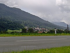
(c) I, Tubantia, CC-BY-SA-3.0 | |||
| |||
| Państwo | |||
|---|---|---|---|
| Kraj związkowy | |||
| Powiat | Innsbruck-Land | ||
| Powierzchnia | 19,64 km² | ||
| Wysokość | 675 m n.p.m. | ||
| Populacja (1 stycznia 2015) • liczba ludności | 1285 | ||
| • gęstość | 65 os./km² | ||
| Numer kierunkowy | 05262 | ||
| Kod pocztowy | 6403 | ||
| Tablice rejestracyjne | IL | ||
| Strona internetowa | |||
Flaurling – gmina w Austrii, w kraju związkowym Tyrol, w powiecie Innsbruck-Land. Według Austriackiego Urzędu Statystycznego liczyła 1285 mieszkańców (1 stycznia 2015)[1].
Przypisy
Media użyte na tej stronie
Autor: Rosso Robot, Licencja: CC BY-SA 3.0
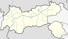
Location map of The Tyrol
Equirectangular projection. Geographic limits of the map:
- N: 47.75317° N
- S: 46.64119° N
- W: 10.08236° E
- E: 12.98961° E
Autor: Lencer, Licencja: CC BY-SA 3.0
Location map of Austria
Equirectangular projection, N/S stretching 150 %. Geographic limits of the map:
- N: 49.2° N
- S: 46.3° N
- W: 9.4° E
- E: 17.2° E
(c) I, Tubantia, CC-BY-SA-3.0
Flaurling, Tyrol, Austria, seen from the village of Unterpettnau


