Flinders Chase National Park
 | |
| Państwo | |
|---|---|
| Data utworzenia | |
| Powierzchnia | 32800 ha |
Położenie na mapie Australii Południowej  | |
Położenie na mapie Australii  | |
| Strona internetowa | |
Flinders Chase National Park - park narodowy w Australii Południowej w południowo-zachodniej części Wyspy Kangura. Powierzchnia parku wynosi 328 km², został on założony w 1919. Podczas pożaru buszu w 2007 park został poważnie zniszczony. Najbardziej znane fragmenty Parku to dwie naturalne formacje skalne Remarkable Rocks i Admirals Arch.
Galeria

Admirals Arch
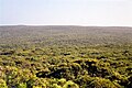
Panorama z punktu widokowegoBunker Hill

Linki zewnętrzne
- Strona oficjalna. environment.sa.gov.au. [zarchiwizowane z tego adresu (2010-04-25)].
Media użyte na tej stronie
Australia relief map.jpg
Autor: , Licencja: CC BY-SA 3.0
Relief map of Australia, including the borders of the states of the Commonwealth of Australia
Autor: , Licencja: CC BY-SA 3.0
Relief map of Australia, including the borders of the states of the Commonwealth of Australia


Green pog.svg
Shiny green button/marker widget.
Shiny green button/marker widget.
Kangaroo Island - Remarkable Rocks.jpg
Autor: Roo72, Licencja: CC BY-SA 2.0 de
"Remarkable Rocks" on Kangaroo Island
Autor: Roo72, Licencja: CC BY-SA 2.0 de
"Remarkable Rocks" on Kangaroo Island

Admirals arch kangaroo island.jpg
Autor: Autor nie został podany w rozpoznawalny automatycznie sposób. Założono, że to Moongateclimber (w oparciu o szablon praw autorskich)., Licencja: CC-BY-SA-3.0
Tourists at Admiral's Arch — in Flinders Chase National Park, Kangaroo Island, South Australia.
Autor: Autor nie został podany w rozpoznawalny automatycznie sposób. Założono, że to Moongateclimber (w oparciu o szablon praw autorskich)., Licencja: CC-BY-SA-3.0
Tourists at Admiral's Arch — in Flinders Chase National Park, Kangaroo Island, South Australia.
Australia South Australia relief location map.png
Autor: Tentotwo, Licencja: CC BY-SA 3.0
Location map of South Australia, Australia
Autor: Tentotwo, Licencja: CC BY-SA 3.0
Location map of South Australia, Australia
Equidistant cylindrical projection, latitude of true scale 31.27° S (equivalent to equirectangular projection with N/S stretching 117 %). Geographic limits of the map:
- N: 25.6° S
- S: 38.5° S
- W: 128.5° E
- E: 141.5° E