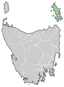
Flinders Council
Flinders Council – obszar samorządu lokalnego (ang. local government area), zlokalizowany na archipelagu wysp Furneaux, wchodzący w skład stanu Tasmania (Australia). Siedziba rady samorządu zlokalizowana jest w miasteczku Whitemark, ponadto na terenie samorządu zlokalizowanych jest trzynaście mniejszych osad: Blue Rocks, Cape Barren Island, Emita, Killiecrankie, Lackrana, Lady Barron, Leeka, Loccota, Lughrata, Memana, Palana, Ranga i Wingaroo[1].
Według danych z 2009 roku, obszar ten zamieszkuje 897 osób[2]. Zamieszkane są jedynie trzy wyspy archipelagu: Flindersa, Cape Barren i Clarke. Powierzchnia samorządu wynosi 1333 km².
W celu identyfikacji samorządu Australian Bureau of Statistics wprowadziło czterocyfrowy kod dla gminy Flinders – 2010[3].
Linki zewnętrzne
- Strona oficjalna. flinders.tas.gov.au. [zarchiwizowane z tego adresu (2007-10-25)].
Przypisy
- ↑ Localities by Council, Local Government Association of Tasmania. lgat.tas.gov.au. [zarchiwizowane z tego adresu (2016-03-04)]., [dostęp 17 czerwca 2010]
- ↑ Australian Bureau of Statistics (30 marca 2010). "Regional Population Growth, Australia, 2008–09", [dostęp 5 lipca 2010].
- ↑ Australian Bureau of Statistics. Alphabetic list of Local Government Areas (LGAs) and Statistical Local Areas (SLAs) – Tasmania, [dostęp 30 września 2011].
Media użyte na tej stronie
Autor: Squiresy92 including elements from Sodacan, Licencja: CC BY-SA 4.0
The Tasmanian Coat of Arms
Autor: unknown, Licencja: CC-BY-SA-3.0
Map of Tasmanian LGA's feat Flinders


