Folkestone and Hythe
| District | |
| Państwo | |
|---|---|
| Kraj | |
| Hrabstwo | |
| Siedziba | |
| Powierzchnia | 356,7 km² |
| Populacja (2011) • liczba ludności |
|
| • gęstość | 303 os./km² |
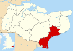
| Położenie na mapie hrabstwa Kent Contains Ordnance Survey data © Crown copyright and database right, CC BY-SA 3.0 | |
| Strona internetowa | |
| Portal | |
Folkestone and Hythe District – dystrykt w Anglii, w południowo-wschodniej części hrabstwa Kent. Centrum administracyjne dystryktu znajduje się w Folkestone.
Dystrykt ma powierzchnię 356,7 km2, leży nad kanałem La Manche zaś od północy graniczy z dystryktami Dover i Canterbury, od zachodu z dystryktem Ashford w hrabstwie Kent i od południa z dystryktem Rother w hrabstwie East Sussex. Zamieszkuje go 107 969 osób.
Na terenie dystryktu znajdują się zamki Lympne[2] i Saltwood[3] oraz Port Lympne Wild Animal Park o powierzchni 2,4 km2 na terenie którego przebywa ponad 650 zwierząt[4]. W Hawkinge znajduje się najstarsze muzeum poświęcone Bitwie o Anglię - Kent Battle of Britain Museum[5].
Na przylądku Dungeness znajduje się otwarta w 1983 roku elektrownia atomowa Dungeness B (planowane zamknięcie w 2018 roku, Dungeness A została zamknięta w 2006 roku)[6].
Podział administracyjny
Dystrykt obejmuje miasta Folkestone, Hawkinge, Hythe, Lydd i New Romney oraz 25 civil parish:
Dystrykt dzieli się na 22 okręgi wyborczych[7]:
|
|
Demografia
W 2011 roku dystrykt Folkestone and Hythe miał 107 969 mieszkańców. Zgodnie ze spisem powszechnym z 2011 roku dystrykt zamieszkiwało 426 osób urodzonych w Polsce[8].
Podział mieszkańców według grup etnicznych na podstawie spisu powszechnego z 2011 roku[9]:
|
|
Podział mieszkańców według wyznania na podstawie spisu powszechnego z 2011 roku[10]:
- Chrześcijaństwo - 62,3%
- Islam – 0,7%
- Hinduizm – 1,4%
- Judaizm – 0,1%
- Buddyzm – 0,9%
- Sikhizm – 0,0%
- Pozostałe religie – 0,5%
- Bez religii – 26,5%
- Nie podana religia – 7,6%
Transport i komunikacja
W Folkstone znajduje się północny terminal Eurotunelu.
Na terenie dystryktu znajdują się stacje Folkestone West i Folkestone Central, które obsługują linie kolei dużej prędkości High Speed 1, na której jeżdżą pociągi Southeastern Highspeed, z tą różnicą, że poruszają się tutaj zwykłymi torami i dopiero na stacji Ashford International w dystrykcie Ashford wjeżdżają na linię High Speed. Ponadto na stacji Folkestone West zatrzymują się luksusowe pociągi turystyczne Venice-Simplon Orient Express.
Pozostałe stacje kolejowe:
- Sandling
- Westenhanger
Ponadto między Hythe a Dungeness na trasie o długości 22 km kursuje kolej wąskotorowa Romney, Hythe and Dymchurch Railway[11]. Zatrzymuje się ona na następujących stacjach: Hythe, Dymchurch, St Mary's Bary, Rommney Warren, New Romney, Romney Sands i Dungeness.
Na terenie dystryktu znajduje się także port lotniczy Lydd które obecnie obsługuje połączenia do Le Touquet-Paris-Plage.
Przez dystrykt przechodzi autostrada M20 a także droga A20 łącząca Dover z centrum Londynu.
Inne miejscowości
Acrise, Arpinge, Barrowhill, Breach, Brenzett, Brookland, Burmarsh, Danton Pinch, Densole, Dymchurch, Elham, Elmsted, Etchinghill, Greatstone-on-Sea, Hawkinge, Ivychurch, Lydd-on-Sea, Lyminge, Lympne, Newchurch, Newingreen, Newington, Old Hawkinge, Old Romney, Paddlesworth, Peene, Postling, Rhodes Minnis, St Mary's Bay, Saltwood, Sandgate, Sandling, Sellindge, Snargate, St Mary in the Marsh, Stanford, Stelling Minnis, Westenhanger, Wingmore.
Przypisy
- ↑ „ons.gov.uk – 2011 Census: KS102EW Age structure, local authorities in England and Wales”
- ↑ „lympnecastle.co.uk – Official site”
- ↑ „saltwoodcastle.com – Official site”
- ↑ „aspinallfoundation.org – Port Lympne”
- ↑ „kbobm.org – Offcial site”
- ↑ „edfenergy.com - Dungeness B ”
- ↑ „shepway.gov.uk - Your Councillors by Ward”
- ↑ „ons.gov.uk – 2011 Census: KS204EW Country of birth, local authorities in England and Wales”
- ↑ „ons.gov.uk – 2011 Census: KS201EW Ethnic group, local authorities in England and Wales”
- ↑ „ons.gov.uk – 2011 Census: KS209EW Religion, local authorities in England and Wales”
- ↑ „rhdr.org.uk – Official website”
Media użyte na tej stronie
Flag of England. Saint George's cross (a red cross on a white background), used as the Flag of England, the Italian city of Genoa and various other places.
Contains Ordnance Survey data © Crown copyright and database right, CC BY-SA 3.0
Map of Kent, UK with Folkestone and Hythe highlighted.
Equirectangular map projection on WGS 84 datum, with N/S stretched 160%Autor: P Montiel, Licencja: CC BY 3.0
Folkestone beach and the Coastal Park from the Leas Cliff Hall
(c) Ian Capper, CC BY-SA 2.0
Lympne Castle This building, parts of which date from the 13th Century, was once occupied by Thomas à Becket.
Male western lowland gorilla contemplating life at port lympne wildlife park.
photo of the site and the lighthouses and nuclear power stations. Dungeness, Kent, UK.
(c) Ron Hann, CC BY-SA 2.0
Hawkinge. A cramped, but interesting, display of material relating to the Battle of Britain.
Autor: Oryginalnym przesyłającym był Nvincer z angielskiej Wikipedii, Licencja: Attribution
Northern Chief at New Romney, Image taken by Ben Vincer


