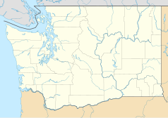
Fort Lewis
 | |
| Państwo | |
|---|---|
| Stan | |
| Rodzaj bazy | |
| Historia | |
| Używana od | 1917 |
| Dane taktyczne | |
| Stacjonujące jednostki | |
| Użytkownicy | |
| 47,0806540°N 122,5812758°W/47,080654 -122,581276 | |
Fort Lewis – baza armii amerykańskiej w stanie Waszyngton, nieopodal miasta Seattle. Stacjonuje tam 2 Dywizja Piechoty.
Linki zewnętrzne
- Strona oficjalna. lewis.army.mil. [zarchiwizowane z tego adresu (2002-12-01)].
- Dane ze strony Global Security
Media użyte na tej stronie
Autor: Uwe Dedering, Licencja: CC BY-SA 3.0
Location map of the USA (without Hawaii and Alaska).
EquiDistantConicProjection:
Central parallel:
* N: 37.0° N
Central meridian:
* E: 96.0° W
Standard parallels:
* 1: 32.0° N
* 2: 42.0° N
Made with Natural Earth. Free vector and raster map data @ naturalearthdata.com.
Formulas for x and y:
x = 50.0 + 124.03149777329222 * ((1.9694462586094064-({{{2}}}* pi / 180))
      * sin(0.6010514667026994 * ({{{3}}} + 96) * pi / 180))
y = 50.0 + 1.6155950752393982 * 124.03149777329222 * 0.02613325650382181
      - 1.6155950752393982  * 124.03149777329222 *
     (1.3236744353715044  - (1.9694462586094064-({{{2}}}* pi / 180))
      * cos(0.6010514667026994 * ({{{3}}} + 96) * pi / 180))
The flag of Navassa Island is simply the United States flag. It does not have a "local" flag or "unofficial" flag; it is an uninhabited island. The version with a profile view was based on Flags of the World and as a fictional design has no status warranting a place on any Wiki. It was made up by a random person with no connection to the island, it has never flown on the island, and it has never received any sort of recognition or validation by any authority. The person quoted on that page has no authority to bestow a flag, "unofficial" or otherwise, on the island.
Autor: Alexrk2, Licencja: CC BY 3.0
Ta mapa została stworzona za pomocą GeoTools.
Łatwo można dodać ramkę naokoło tej grafiki
Autor: Squelle, Licencja: CC BY-SA 3.0
View of four Chinook helicopters over airfield at Ft. Lewis.


