Frankfort (Ohio)
| Państwo | |
|---|---|
| Stan | |
| Populacja • liczba ludności |
|
| Kod pocztowy | 45628 |
Położenie na mapie Ohio  | |
Położenie na mapie Stanów Zjednoczonych  | |
| 39,4056°N 83,1822°W/39,405600 -83,182200 | |
| Portal | |

Frankfort na planie stanu Ohio
Frankfort – wieś w USA, w stanie Ohio, w Hrabstwie Ross.
Liczba mieszkańców w 2010 roku wynosiła 1 064, a w roku 2012 – 1 065.
Galeria

Tablica informująca.
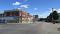
Skrzyżowanie ulic we Frankforcie.

Wieża ciśnień we Frankforcie.

Dom we Frankforcie.
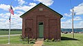
Budynek szkoły zbudowany w 1877, we Frankforcie.
Linki zewnętrzne
- Dane statystyczne [1]
Kontrola autorytatywna (wieś w Stanach Zjednoczonych):
Media użyte na tej stronie
USA Ohio location map.svg
Autor: Alexrk2, Licencja: CC BY 3.0
Ta mapa została stworzona za pomocą GeoTools.
Autor: Alexrk2, Licencja: CC BY 3.0
Ta mapa została stworzona za pomocą GeoTools.
Usa edcp location map.svg
Autor: Uwe Dedering, Licencja: CC BY-SA 3.0
Location map of the USA (without Hawaii and Alaska).
Autor: Uwe Dedering, Licencja: CC BY-SA 3.0
Location map of the USA (without Hawaii and Alaska).
EquiDistantConicProjection:
Central parallel:
* N: 37.0° N
Central meridian:
* E: 96.0° W
Standard parallels:
* 1: 32.0° N
* 2: 42.0° N
Made with Natural Earth. Free vector and raster map data @ naturalearthdata.com.
Formulas for x and y:
x = 50.0 + 124.03149777329222 * ((1.9694462586094064-({{{2}}}* pi / 180))
      * sin(0.6010514667026994 * ({{{3}}} + 96) * pi / 180))
y = 50.0 + 1.6155950752393982 * 124.03149777329222 * 0.02613325650382181
      - 1.6155950752393982  * 124.03149777329222 *
     (1.3236744353715044  - (1.9694462586094064-({{{2}}}* pi / 180))
      * cos(0.6010514667026994 * ({{{3}}} + 96) * pi / 180))

Flag of the United States.svg
The flag of Navassa Island is simply the United States flag. It does not have a "local" flag or "unofficial" flag; it is an uninhabited island. The version with a profile view was based on Flags of the World and as a fictional design has no status warranting a place on any Wiki. It was made up by a random person with no connection to the island, it has never flown on the island, and it has never received any sort of recognition or validation by any authority. The person quoted on that page has no authority to bestow a flag, "unofficial" or otherwise, on the island.
The flag of Navassa Island is simply the United States flag. It does not have a "local" flag or "unofficial" flag; it is an uninhabited island. The version with a profile view was based on Flags of the World and as a fictional design has no status warranting a place on any Wiki. It was made up by a random person with no connection to the island, it has never flown on the island, and it has never received any sort of recognition or validation by any authority. The person quoted on that page has no authority to bestow a flag, "unofficial" or otherwise, on the island.


FrankfortOH4.JPG
Autor: Aesopposea, Licencja: CC BY-SA 3.0
The Red Brick Schoolhouse, constructed in 1877, located in Twin Township, Ross County, Ohio.
Autor: Aesopposea, Licencja: CC BY-SA 3.0
The Red Brick Schoolhouse, constructed in 1877, located in Twin Township, Ross County, Ohio.

House in Frankfort, Ohio.jpg
Autor: dok1, Licencja: CC BY 2.0
House in Frankfort, Ross County, Ohio, United States.
Autor: dok1, Licencja: CC BY 2.0
House in Frankfort, Ross County, Ohio, United States.


FrankfortOH2.JPG
Autor: Aesopposea, Licencja: CC BY-SA 3.0
Intersection of Main Street and Springfield Street in Frankfort, Ohio.
Autor: Aesopposea, Licencja: CC BY-SA 3.0
Intersection of Main Street and Springfield Street in Frankfort, Ohio.