Freudenberg (Nadrenia Północna-Westfalia)
 | |||||
| Państwo | |||||
|---|---|---|---|---|---|
| Kraj związkowy | |||||
| Powierzchnia | 54,49 km² | ||||
| Wysokość | 330 m n.p.m. | ||||
| Populacja (31 grudnia 2010) • liczba ludności • gęstość |
| ||||
| Nr kierunkowy | 02734 | ||||
| Kod pocztowy | 57258 | ||||
| Tablice rejestracyjne | SI, BLB | ||||
 | |||||
| Strona internetowa | |||||
| Portal | |||||
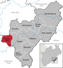
Freudenberg [ˈfʁɔʏ̯dn̩ˌbɛʁk] – miasto w Niemczech, położone w kraju związkowym Nadrenia Północna-Westfalia, w rejencji Arnsberg, w powiecie Siegen-Wittgenstein. W 2010 roku liczyło 18 392 mieszkańców[1].
Linki zewnętrzne
Przypisy
- ↑ IT.NRW Amtliche Bevölkerungszahlen. it.nrw.de. [zarchiwizowane z tego adresu (2011-07-29)]. (niem.) (urzędowe liczby mieszkańców dla Nadrenii Północnej-Westfalii)
Media użyte na tej stronie
Autor: Hanhil based on previous work by TUBS, Licencja: CC BY-SA 3.0
Location map North Rhine-Westphalia showing position of NRW within Germany. Geographic limits of the map:
Autor: NordNordWest, Licencja: CC BY-SA 3.0
Location map of Germany (Wp article: en:Germany)
Beschreibung des Banners:"Die Flagge zeigt längs gestreift die Farben blau und gold (gelb) und in der oberen Hälfte das Stadtwappen." Die Stadt Freudenberg führt eine Stadtflagge. Dieses Recht ist ihr zuletzt am 24. Juni 1970 vom Regierungspräsidenten Arnsberg verliehen worden.
Autor: Christian Stamm, Licencja: CC-BY-SA-3.0
Historical center of Freudenberg, Westphalia (Alter Flecken)
Autor: TUBS, Licencja: CC BY-SA 3.0
|
|
|
|
|
|
|
|


