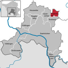
Friedrichsthal
 | |||
| |||
| Państwo | |||
|---|---|---|---|
| Kraj związkowy | |||
| Powierzchnia | 9,07 km² | ||
| Wysokość | 300 m n.p.m. | ||
| Populacja (31 grudnia 2010) • liczba ludności • gęstość |
| ||
| Nr kierunkowy | 06897 | ||
| Kod pocztowy | 66299 | ||
| Tablice rejestracyjne | SB | ||
 | |||
| Strona internetowa | |||
| Portal | |||
Friedrichsthal – miasto w Niemczech, w kraju związkowym Saara, w związku regionalnym Saarbrücken. W 2010 liczyło 10 798 mieszkańców.
Współpraca
Miejscowości partnerskie[1]:
- Oranienburg, Brandenburgia
- Villingen-Schwenningen, Badenia-Wirtembergia (kontakty utrzymuje dzielnica Bildstock)
Bibliografia
- Statistisches Amt Saarland, Saarbrücken
Przypisy
Media użyte na tej stronie
Autor: NordNordWest, Licencja: CC BY-SA 3.0
Location map of Germany (Wp article: en:Germany)
|
|
|
|
|
|
|
|
Autor: Hanhil based on work by Lantus, Licencja: CC BY-SA 3.0
Position map of the state of Saarland, showing position of Saarland within Germany with the six disticts and fiftytwo municipalities
Geographic limits of the map: * N: 49.65° N * S: 49.09° N * W: 6.3° E * E: 7.405° E
Autor: atreyu, Licencja: CC BY-SA 3.0
Blick vom Hoferkopf-Turm auf Bildstock, einem Stadtteil von Friedrichsthal, Regionalverband Saarbrücken, Saarland


