Fukushima
| |||||||
 | |||||||
| Państwo | |||||||
|---|---|---|---|---|---|---|---|
| Prefektura | Fukushima | ||||||
| Wyspa | Honsiu | ||||||
| Region | Tōhoku | ||||||
| Burmistrz | Hiroshi Kohata | ||||||
| Powierzchnia | 767,72[1] km² | ||||||
| Populacja (2020) • liczba ludności • gęstość | 282 802[2] 368 os./km² | ||||||
| Nr kierunkowy | (+81) 24 | ||||||
| Kod pocztowy | 960-8601 | ||||||
| Symbole japońskie | |||||||
| Drzewo | Brzostownica japońska | ||||||
| Kwiat | Kwiat brzoskwini | ||||||
| Ptak | Sikora bogatka | ||||||
| Strona internetowa | |||||||
| Portal | |||||||
Fukushima (jap. 福島市 Fukushima-shi) – stolica prefektury o tej samej nazwie, położona w Regionie Tōhoku w Japonii. Fukushimę dzieli od Tokio 250 kilometrów, a od Sendai 80 km. Ma powierzchnię 767,72 km2 [1]. W 2020 r. mieszkały w nim 282 802 osoby, w 121 342 gospodarstwach domowych[2] (w 2010 r. 292 280 osób, w 113 073 gospodarstwach domowych)[3].
W 2011 doszło do serii wypadków jądrowych w Elektrowni Atomowej Fukushima Nr 1.
W mieście rozwinął się przemysł włókienniczy, chemiczny, drzewny, maszynowy, spożywczy, szklarski oraz elektrotechniczny[4].
Przypisy
- ↑ a b Geospatial Information Authority of Japan 2021 ↓, s. 19.
- ↑ a b Statistics Bureau of Japan 2021 ↓.
- ↑ Statistics Bureau of Japan 2011 ↓, s. 14.
- ↑ Fukushima, [w:] Encyklopedia PWN [online] [dostęp 2021-10-04].
Bibliografia
- Geospatial Information Authority of Japan: 令和3年 全国都道府県市区町村別面積調 (1月1日時点) (Reiwa 3rd year Area adjustment by prefecture, city, ward, town, and village (As of January 1)) (jap.). gsi.go.jp, 2021. [dostęp 2021-09-13]. [zarchiwizowane z tego adresu (2021-06-05)].
- Statistics Bureau, Ministry of Internal Affairs and Communications: Preliminary Counts of the Population and Households (ang.). W: 2020 Population Census [on-line]. e-stat.go.jp Portal Site of Official Statistics of Japan, 2021. [dostęp 2021-09-13].
- 平成22年国勢調査 – 人口速報集計結果 (2010 Census - Population Bulletin Aggregation Results) (jap.). e-stat.go.jp Portal Site of Official Statistics of Japan, 2011. [dostęp 2021-09-13].
Media użyte na tej stronie
Autor: Maximilian Dörrbecker (Chumwa), Licencja: CC BY-SA 3.0
Location map of Japan
Equirectangular projection.
Geographic limits to locate objects in the main map with the main islands:
- N: 45°51'37" N (45.86°N)
- S: 30°01'13" N (30.02°N)
- W: 128°14'24" E (128.24°E)
- E: 149°16'13" E (149.27°E)
Geographic limits to locate objects in the side map with the Ryukyu Islands:
- N: 39°32'25" N (39.54°N)
- S: 23°42'36" N (23.71°N)
- W: 110°25'49" E (110.43°E)
- E: 131°26'25" E (131.44°E)
Flag of Fukushima Prefecture.
Autor: Created by LERK, Licencja: Copyrighted free use
The shadow picture of Fukushima Prefecture, Japan
Autor: Purplepumpkins, Licencja: CC BY-SA 3.0
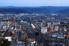
This is a view of Fukushima City, Fukushima Prefecture, Japan centered upon Fukushima Station. Running from south (top of photo) to north (bottom of photo), the Tohoku Shinkansen connects Tokyo with the northeastern part of Honshu island, running all the way up to Aomori Prefecture. Fukushima Station's importance lies in that it's where the Yamagata Shinkansen (bottom right) splits off from the Tohoku Shinkansen and heads off on its own.
Flag of Fukushima, Fukushima
Autor: Mliu92, Licencja: CC BY-SA 4.0
Fukushima Fukushima chapter. Vector traced from raster.


