Góry Aleuckie
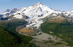
 Lodowiec na stoku wulkanu Iliamna w paśmie Gór Aleuckich | |
| Kontynent | |
|---|---|
| Państwo | |
| Stan | |
| Najwyższy szczyt | Redoubt, 3108 m n.p.m. |
 Mapa półwyspu Alaska; widoczna większa część pasma Gór Aleuckich, północno-wschodni skraj pasma poza mapą | |
Góry Aleuckie[1] (ang. Aleutian Range) – pasmo górskie w południowo-zachodniej Alasce (Stany Zjednoczone), rozciągające się na całej długości półwyspu Alaska oraz wzdłuż zachodniego wybrzeża Zatoki Cooka. Całkowita długość pasma wynosi około 1000 km. Na północnym wschodzie pasmo dociera do jeziora Ch'akajabena (Chakachamna), gdzie styka się z górami Alaska. Góry znajdują się na terenie okręgów administracyjnych Lake and Peninsula, Kenai Peninsula i Aleutians East[2].
W paśmie znajdują się liczne szczyty wulkaniczne, m.in. Redoubt (najwyższy szczyt pasma, 3108 m n.p.m.), Iliamna (3053 m n.p.m.), Veniaminof (2507 m n.p.m.) i Katmai (2047 m n.p.m.)[3][4].
Fragmenty pasma znajdują się w obrębie parków narodowych Lake Clark i Katmai oraz pomnika narodowego i rezerwatu przyrody Aniakchak[3].
Przypisy
- ↑ Urzędowy wykaz polskich nazw geograficznych świata. Główny Urząd Geodezji i Kartografii, 2019. s. 615. [dostęp 2022-10-15].
- ↑ Aleutian Range, [w:] Geographic Names Information System (GNIS) [online], U.S. Geological Survey (USGS) [dostęp 2022-10-15] (ang.).
- ↑ a b Aleutian Range, [w:] Encyclopædia Britannica [online] [dostęp 2022-10-15] (ang.).
- ↑ Aleutian Ranges. PeakBagger. [dostęp 2022-10-15]. (ang.).
Media użyte na tej stronie
The flag of Navassa Island is simply the United States flag. It does not have a "local" flag or "unofficial" flag; it is an uninhabited island. The version with a profile view was based on Flags of the World and as a fictional design has no status warranting a place on any Wiki. It was made up by a random person with no connection to the island, it has never flown on the island, and it has never received any sort of recognition or validation by any authority. The person quoted on that page has no authority to bestow a flag, "unofficial" or otherwise, on the island.
Black up-pointing triangle ▲, U+25B2 from Unicode-Block Geometric Shapes (25A0–25FF)
Autor: Uwe Dedering, Licencja: CC BY-SA 3.0
Relief location map of North America.
- Projection: Lambert azimuthal equal-area projection.
- Area of interest:
- N: 90.0° N
- S: 5.0° N
- W: -140.0° E
- E: -60.0° E
- Projection center:
- NS: 47.5° N
- WE: -100.0° E
- GMT projection: -JA-100/47.5/20.0c
- GMT region: -R-138.3726888474925/-3.941007863604182/2.441656573833029/50.63933645705661r
- GMT region for grdcut: -R-220.0/-4.0/20.0/90.0r
- Relief: SRTM30plus.
- Made with Natural Earth. Free vector and raster map data @ naturalearthdata.com.
A glacier flows out from Iliamna Volcano towards a broad outwash plain along the Johnson River in this aerial photo taken near Silver Salmon Creek.
Autor: Wikisoft* @@@-fr 07:08, 27 April 2011 (UTC), Licencja: GFDL
Carte Alaska Relief R3 jpg (Changement des couleurs)


