Góry Zielone (Ameryka Północna)
 Góry Zielone | |
| Kontynent | |
|---|---|
| Państwo | |
| Najwyższy szczyt | Mount Mansfield |
| Długość | 400 km |
| Jednostka dominująca | Appalachy |
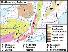
 Mapa Appalachów w północno-wschodnich USA; Góry Zielone zaznaczone na zielono | |
| 44°47′30″N 72°34′58″W/44,791667 -72,582778 | |
Góry Zielone (ang. Green Mountains, fr. Montagnes Vertes) – pasmo górskie w stanach Vermont i Massachusetts (Stany Zjednoczone) oraz prowincji Quebec (Kanada), wchodzące w skład Appalachów.
Ciągnie się na długości ok. 400 km na osi północ-południe. Ich południową część stanowią Berkshires w Massachusetts, a północną Monts Sutton w kanadyjskim Quebecu.
Najwyższe szczyty:
- Mount Mansfield (1339 m n.p.m.)
- Killington Peak (1292 m n.p.m.)
- Mount Ellen (1244 m n.p.m.)
- Camel's Hump (1244 m n.p.m.).
Media użyte na tej stronie
Autor: Uwe Dedering, Licencja: CC BY-SA 3.0
Relief location map of North America.
- Projection: Lambert azimuthal equal-area projection.
- Area of interest:
- N: 90.0° N
- S: 5.0° N
- W: -140.0° E
- E: -60.0° E
- Projection center:
- NS: 47.5° N
- WE: -100.0° E
- GMT projection: -JA-100/47.5/20.0c
- GMT region: -R-138.3726888474925/-3.941007863604182/2.441656573833029/50.63933645705661r
- GMT region for grdcut: -R-220.0/-4.0/20.0/90.0r
- Relief: SRTM30plus.
- Made with Natural Earth. Free vector and raster map data @ naturalearthdata.com.
The flag of Navassa Island is simply the United States flag. It does not have a "local" flag or "unofficial" flag; it is an uninhabited island. The version with a profile view was based on Flags of the World and as a fictional design has no status warranting a place on any Wiki. It was made up by a random person with no connection to the island, it has never flown on the island, and it has never received any sort of recognition or validation by any authority. The person quoted on that page has no authority to bestow a flag, "unofficial" or otherwise, on the island.
Flag of Canada introduced in 1965, using Pantone colors. This design replaced the Canadian Red Ensign design.
Autor: Uwe Dedering, Licencja: CC BY-SA 3.0
Relief location map of North America.
- Projection: Lambert azimuthal equal-area projection.
- Area of interest:
- N: 90.0° N
- S: 5.0° N
- W: -140.0° E
- E: -60.0° E
- Projection center:
- NS: 47.5° N
- WE: -100.0° E
- GMT projection: -JA-100/47.5/20.0c
- GMT region: -R-138.3726888474925/-3.941007863604182/2.441656573833029/50.63933645705661r
- GMT region for grdcut: -R-220.0/-4.0/20.0/90.0r
- Relief: SRTM30plus.
- Made with Natural Earth. Free vector and raster map data @ naturalearthdata.com.
Black up-pointing triangle ▲, U+25B2 from Unicode-Block Geometric Shapes (25A0–25FF)
Autor: Pfly, Licencja: CC BY-SA 2.5
Map of the main mountain ranges of the northeast Appalachians
Autor: Oryginalnym przesyłającym był Redjar z angielskiej Wikipedii, Licencja: CC-BY-SA-3.0
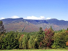
Description: Photograph of en:Mount Mansfield
Source: Photograph taken by Jared C. Benedict on 26 September 2004. Full resolution original available at: redjar.org/gallery/wikipedia_photos.
Copyright: © Jared C. Benedict.
en:Category:Stowe, Vermont


