Gainesville (Floryda)
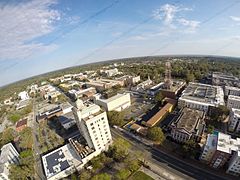
 Panorama Gainesville | |||
| |||
| Państwo | |||
|---|---|---|---|
| Stan | |||
| Hrabstwo | |||
| Prawa miejskie | 1907[1] | ||
| Burmistrz | Lauren Poe | ||
| Powierzchnia | 167,1 km² | ||
| Wysokość | 54 m n.p.m. | ||
| Populacja (2020) • liczba ludności • gęstość |
| ||
| Nr kierunkowy | 352 | ||
| Kod pocztowy | 32601–32614, 32627, 32635, 32641, 32653 | ||
| Strona internetowa | |||
| Portal | |||
Gainesville – miasto w Stanach Zjednoczonych, w północnej części stanu Floryda. Według spisu w 2020 roku liczy 141,1 tys. mieszkańców i jest trzynastym co do wielkości miastem Florydy[2].
University of Florida i UF Health Hospital są wiodącymi pracodawcami w Gainesville i zapewniają pracę wielu mieszkańcom okolicznych hrabstw. Znane z zabytkowych budynków, oraz liczne parki, muzea i jeziora zapewniają rozrywkę tysiącom odwiedzających. Ze względu na krajobraz i miejski „las”, Gainesville jest uznawane za jedno z najbardziej atrakcyjnych miast na Florydzie[3].
Siedziba stanowego Uniwersytetu Florydy, zwanego potocznie Florida Gators (od: aligators).
W mieście rozwinął się przemysł drzewny[1].
Mieszkał tu Henryk Mehlberg.
Urodzeni w Gainesville
- Tom Petty – muzyk rockowy[4]
- Desmond Child – muzyk i producent
- Benmont Tench – muzyk i piosenkarz
- Don Felder – muzyk rockowy
- Scott Ritter – pisarz, oficer wywiadu i inspektor broni ONZ
- Jearl Miles-Clark – mistrzyni świata i mistrzyni olimpijska specjalizująca się w biegach krótkich
- Gus Bilirakis – amerykański polityk, kongresmen
- Charles Bradley – amerykański wokalista soulowy
- Rodney Mullen – amerykański skater
Miasta partnerskie
Galeria
- (c) Raman Patel, CC BY 3.0
Panorama głównej ulicy
Stadion Florida Gators
Przypisy
- ↑ a b Gainesville, [w:] Encyklopedia PWN [online] [dostęp 2021-10-04].
- ↑ U.S. Census Bureau QuickFacts: Gainesville city, Florida; Florida, www.census.gov [dostęp 2022-10-20] (ang.).
- ↑ City of Gainesville Facts, www.gainesvillefl.gov [dostęp 2022-10-20] (ang.).
- ↑ Famous People From Gainesville, Florida - #1 is Tom Petty, Playback.fm [dostęp 2022-10-20] (ang.).
Media użyte na tej stronie
Autor: Uwe Dedering, Licencja: CC BY-SA 3.0
Location map of the USA (without Hawaii and Alaska).
EquiDistantConicProjection:
Central parallel:
* N: 37.0° N
Central meridian:
* E: 96.0° W
Standard parallels:
* 1: 32.0° N
* 2: 42.0° N
Made with Natural Earth. Free vector and raster map data @ naturalearthdata.com.
Formulas for x and y:
x = 50.0 + 124.03149777329222 * ((1.9694462586094064-({{{2}}}* pi / 180))
      * sin(0.6010514667026994 * ({{{3}}} + 96) * pi / 180))
y = 50.0 + 1.6155950752393982 * 124.03149777329222 * 0.02613325650382181
      - 1.6155950752393982  * 124.03149777329222 *
     (1.3236744353715044  - (1.9694462586094064-({{{2}}}* pi / 180))
      * cos(0.6010514667026994 * ({{{3}}} + 96) * pi / 180))
The flag of Navassa Island is simply the United States flag. It does not have a "local" flag or "unofficial" flag; it is an uninhabited island. The version with a profile view was based on Flags of the World and as a fictional design has no status warranting a place on any Wiki. It was made up by a random person with no connection to the island, it has never flown on the island, and it has never received any sort of recognition or validation by any authority. The person quoted on that page has no authority to bestow a flag, "unofficial" or otherwise, on the island.
Flag of Israel. Shows a Magen David (“Shield of David”) between two stripes. The Shield of David is a traditional Jewish symbol. The stripes symbolize a Jewish prayer shawl (tallit).
Autor: Michael Rivera, Licencja: CC BY-SA 4.0
State Attorney's Office, Gainesville, Alachua County, Florida
(c) Raman Patel, CC BY 3.0
South West 16th Ave, Greensille, FL
Autor: WillMcC, Licencja: CC BY-SA 3.0
The Rosa Parks downtown station is a hub for the Gainesville Regional Transit System. Several Gillig Low-Floor buses are visible.
Autor: unknown, Licencja: CC BY 2.0
Autor: Flatwoods 36, Licencja: CC BY-SA 4.0
The Cade Museum at Depot Park in Gainesville. Photo taken looking south down Main Street.
Autor: Pablo Corredor, Licencja: CC BY-SA 4.0
Picture taken July 2015 of Ben Hill Griffin Stadium at the University of Florida
Autor: LittleT889, Licencja: CC BY-SA 4.0
Saint Francis Academy (Gainesville, Florida)


