Gaja (Bihar)
 | |
| Państwo | |
|---|---|
| Stan | Bihar |
| Dystrykt | Gaya |
| Burmistrz | Rana Avdhesh Kumar Singh |
| Populacja (2011) • liczba ludności | 463454 |
| Nr kierunkowy | 631 |
| Kod pocztowy | 823001 |
Położenie na mapie Indii | |
| Strona internetowa | |
Gaja (hindi गया, trl. Gayā, trb. Gaja; ang. Gaya) – miasto w północnych Indiach w środkowej części stanu Bihar, ok. 100 km na południe od Gangesu i od stolicy stanu Patny, na szlaku kolejowym do Kolkaty, na pograniczu wyżyny Ćhota Nagpur i Niziny Hindustańskiej. Około 460 tys. mieszkańców. Jest stolicą dystryktu Gaya. Leży nad rzeką Falgu. W średniowieczu wchodziło w skład stanu Magadha. Graniczy od południa (11 km) ze sławnym buddyjskim ośrodkiem kultowym Bodh Gaja.
Ciekawe miejsca
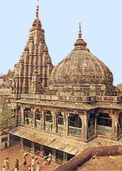
- Świątynia Wisznupad
- Świątynia Baheśwari Dew
- Świątynia Sitala Mai
- wzgórze Brahmawani
Media użyte na tej stronie
(c) Uwe Dedering z niemieckiej Wikipedii, CC BY-SA 3.0
Location map of India.
Equirectangular projection. Strechted by 106.0%. Geographic limits of the map:
- N: 37.5° N
- S: 5.0° N
- W: 67.0° E
- E: 99.0° E
The Flag of India. The colours are saffron, white and green. The navy blue wheel in the center of the flag has a diameter approximately the width of the white band and is called Ashoka's Dharma Chakra, with 24 spokes (after Ashoka, the Great). Each spoke depicts one hour of the day, portraying the prevalence of righteousness all 24 hours of it.
Vishnupadh temple Gaya
Autor: NordNordWest, Licencja: CC BY-SA 3.0 de
Location map of Bihar, India


