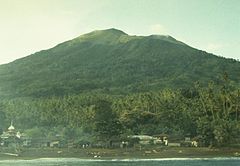
Gamkonora
 | |
| Państwo | |
|---|---|
| Położenie | Halmahera Barat |
| Wysokość | 1635 m n.p.m. |
| Dane wulkanu | |
| Typ wulkanu | |
| Aktywność | |
| 1°22′48″N 127°31′48″E/1,380000 127,530000 | |
Gamkonora (indonez. Gunung Gamkonora), także: Gamkunora[2], Gammacanore[2], Gamkunoro[1] – stratowulkan położony na wyspie Halmahera w archipelagu Moluków we wschodniej Indonezji[3]. W okresie od 1564 do 1989 doszło do dwunastu erupcji wulkanu[4].
Zobacz też
- język gamkonora
Przypisy
- ↑ a b Halmahera, [w:] Encyklopedia PWN [online] [dostęp 2020-10-22] [zarchiwizowane z adresu 2020-10-22].
- ↑ a b G. Gamkonora. Badan Geologi, 2014-05-30. [dostęp 2020-10-22]. [zarchiwizowane z tego adresu (2020-10-22)]. (indonez.).
- ↑ Gamkonora. [w:] Global Volcanism Program [on-line]. Smithsonian Institution. [dostęp 2020-10-22]. [zarchiwizowane z tego adresu (2020-10-22)]. (ang.).
- ↑ Lindsay McClelland (red.): Global Volcanism 1975-1985. Prentice Hall, 1989, s. 231. ISBN 0-13-357203-X. (ang.).
Media użyte na tej stronie
Autor: Uwe Dedering, Licencja: CC BY-SA 3.0
Location map of Indonesia.
Equirectangular projection. Strechted by 100.0%. Geographic limits of the map:
- N: 6.5° N
- W: 94.5° E
- E: 141.5° E
- S: -11.5° N
bendera Indonesia
Black up-pointing triangle ▲, U+25B2 from Unicode-Block Geometric Shapes (25A0–25FF)
Gamkonora volcano, seen here from the NW coast near Gamsungi village, is one of Halmahera's more active volcanoes. The summit crater of Gamkonora is elongated in a N-S direction, with a small crater lake at the north end. The first two historical eruptions, in 1564 or 1565, and in 1693, were the most severe, producing respectively a destructive lava flow that reached the sea, and a tsunami that inundated villages.


