Gants Hill
| ||
 | ||
| Państwo | ||
| Miejscowość | Londyn | |
| Data otwarcia | 1947 | |
| Liczba peronów | 2 | |
| Central Line | ||
| Poprzednia stacja | Redbridge | |
| Następna stacja | Newbury Park | |
Położenie na mapie gminy Redbridge  Contains Ordnance Survey data © Crown copyright and database right, CC BY-SA 3.0 | ||
Położenie na mapie Wielkiej Brytanii  (c) Karte: NordNordWest, Lizenz: Creative Commons by-sa-3.0 de | ||
Położenie na mapie Anglii  | ||
Położenie na mapie Wielkiego Londynu  Contains Ordnance Survey data © Crown copyright and database right, CC BY-SA 3.0 | ||
| Portal | ||
Gants Hill – stacja londyńskiego metra położona na trasie Central Line pomiędzy stacjami Redbridge a Newbury Park. Znajduje się w dzielnicy Gants Hill w gminie London Borough of Redbridge, w czwartej strefie biletowej[1]. Stacja funkcjonuje od 14 grudnia 1947[2] W 2010 roku obsłużyła 5,060 miliona pasażerów[3].
W czasie II wojny światowej tunele stacji służyły jako schrony i składy amunicji. Znajdowały się w nich również linie produkcyjne części do samolotów firmy Plessey[2].
Połączenia
Stacja obsługiwana jest przez autobusy linii 66, 123, 128, 150, 167, 179, 296, 396 i 462.
Galeria
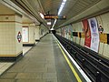
Platfoma w kierunku wschodnim

Platfoma w kierunku zachodnim
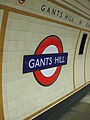
Symbol stacji
Przypisy
- ↑ Tube stations - Gants Hill. Transport for London. [dostęp 2012-01-10].
- ↑ a b Central line facts (ang.). Transport For London. [dostęp 2012-01-10].
- ↑ Customer metrics: entries and exits (ang.). Transport For London. [dostęp 2012-01-04].
| Linia główna | |
|---|---|
| Odgałęzienie West Ruislip | |
| Odgałęzienie Ealing Broadway | |
| Odgałęzienie Woodford | |
| Odgałęzienie Epping |
![]()
Media użyte na tej stronie
(c) Karte: NordNordWest, Lizenz: Creative Commons by-sa-3.0 de
Location map of the United Kingdom
Contains Ordnance Survey data © Crown copyright and database right, CC BY-SA 3.0
Map of Greater London, UK with the following information shown:
- Administrative borders
- Coastline, lakes and rivers
- Roads and railways
- Urban areas
The data includes both primary routes and railway lines.
Equirectangular map projection on WGS 84 datum, with N/S stretched 160%
Geographic limits:
- West: 0.57W
- East: 0.37E
- North: 51.72N
- South: 51.25N


Contains Ordnance Survey data © Crown copyright and database right, CC BY-SA 3.0
Blank map of the London Borough of Redbridge, showing electoral wards.
Equirectangular map projection on WGS 84 datum, with N/S stretched 160%
Geographic limits:
- West: 0
- East: 0.16E
- North: 51.635N
- South: 51.535N

Autor: Sunil060902, Licencja: CC BY-SA 3.0
Gants Hill tube station westbound platform looking east
Autor: Sunil060902, Licencja: CC BY-SA 3.0
Gants Hill tube station southwest entrance, with the newly refurbished City Gate House tower block (now residential) in the background. This entrance lies in between the A12 Eastern Avenue (on the left) and Clarence Avenue. The station itself lies directly beneath Gants Hill roundabout.

Autor: Sunil060902, Licencja: CC BY-SA 3.0
Gants Hill tube station platform roundel

Autor: Sunil060902, Licencja: CC BY-SA 3.0
Gants Hill tube station eastbound platform looking west