Gateshead
 | |
| Państwo | |
|---|---|
| Hrabstwo ceremonialne | |
| Unitary authority | |
| Populacja (2001) • liczba ludności |
|
| Nr kierunkowy | 0191 |
| Kod pocztowy | NE8-NE11 |
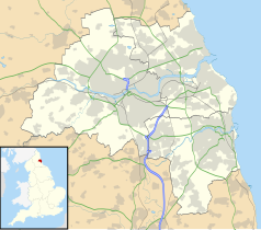
Położenie na mapie Tyne and Wear Contains Ordnance Survey data © Crown copyright and database right, CC BY-SA 3.0 | |
Położenie na mapie Wielkiej Brytanii (c) Karte: NordNordWest, Lizenz: Creative Commons by-sa-3.0 de | |
| Strona internetowa | |
| Portal | |
Gateshead – miasto w północno-wschodniej części Anglii, w hrabstwie Tyne and Wear, w dystrykcie (unitary authority) Gateshead, położone na południowym brzegu rzeki Tyne, naprzeciw Newcastle upon Tyne; stanowi część aglomeracji Tyneside. W 2001 roku miasto liczyło 78 403 mieszkańców[1].
W mieście rozwinął się przemysł maszynowy, metalowy, spożywczy, lekki oraz hutniczy[2].
Przypisy
- ↑ KS01 Usual resident population: Census 2001, Key Statistics for urban areas. Office for National Statistics. [dostęp 2015-12-15]. [zarchiwizowane z tego adresu (2004-07-23)]. (ang.).
- ↑ Gateshead, [w:] Encyklopedia PWN [online] [dostęp 2021-07-03].
Linki zewnętrzne
Media użyte na tej stronie
(c) Karte: NordNordWest, Lizenz: Creative Commons by-sa-3.0 de
Location map of the United Kingdom
Contains Ordnance Survey data © Crown copyright and database right, CC BY-SA 3.0
Map of Tyne and Wear, UK, with the following information shown:
- Administrative borders
- Coastline, lakes and rivers
- Roads and railways
- Urban areas
Equirectangular map projection on WGS 84 datum, with N/S stretched 170%
Geographic limits:
- West: 1.90W
- East: 1.30W
- North: 55.09N
- South: 54.78N
Gateshead Millennium Bridge at the time when Cars were floating in the River Tyne for Artwork (summer 2006).


