Gemert
| |||||
| Państwo | |||||
|---|---|---|---|---|---|
| Prowincja | |||||
| Gmina | |||||
| Populacja (2009) • liczba ludności |
| ||||
| Kod pocztowy | 5421 | ||||
Położenie na mapie Brabancji Północnej  | |||||
Położenie na mapie Holandii  | |||||
| Strona internetowa | |||||
Gemert – wieś w Holandii w prowincji Brabancja Północna. 1 stycznia 2009 roku liczba ludności wynosiła 15 268 osób. Największe miasto i jedna z dwóch stolic gminy Gemert-Bakel.

(c) Wvdburgt, CC-BY-SA-3.0
Zamek komtura Gemert
Tutejszy zamek był siedzibą komtura zakonu krzyżackiego stojącego na czele komandorii Gemert.
Galeria

Gemert
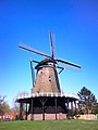
Wiatrak w Gemert
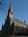
Kościół św. Jana
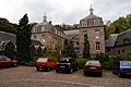
Zamek Gemert
Media użyte na tej stronie

.JPG)
Gemert (8).JPG
Autor: Kasteelbeer, Licencja: CC BY-SA 3.0 nl
To jest zdjęcie holenderskiego zabytku (rijksmonument) numer 16049
Autor: Kasteelbeer, Licencja: CC BY-SA 3.0 nl
To jest zdjęcie holenderskiego zabytku (rijksmonument) numer 16049

Gemert1.jpg
Gemert
Gemert


Netherlands North Brabant location map.svg
Autor: Erik Frohne, Licencja: CC BY-SA 3.0
Location map of province North Brabant in the Netherlands
Autor: Erik Frohne, Licencja: CC BY-SA 3.0
Location map of province North Brabant in the Netherlands
Equirectangular projection, N/S stretching 161 %. Geographic limits of the map:
- N: 51.90° N
- S: 51.20° N
- W: 4.10° E
- E: 6.10° E

Kasteel gemert 2.JPG
(c) Wvdburgt, CC-BY-SA-3.0
To jest zdjęcie holenderskiego zabytku (rijksmonument) numer 16049
(c) Wvdburgt, CC-BY-SA-3.0
To jest zdjęcie holenderskiego zabytku (rijksmonument) numer 16049

Kerk van Sint-Jans Onthoofding P1050902.JPG
Autor: G.Lanting, Licencja: CC BY-SA 3.0
Kerk van Sint-Jans Onthoofding in Gemert
Autor: G.Lanting, Licencja: CC BY-SA 3.0
Kerk van Sint-Jans Onthoofding in Gemert

Flag of Gemert.png
Municipal flag predating the 1997 rearrangement of municipalities
Municipal flag predating the 1997 rearrangement of municipalities