Gerbrunn
| gmina | |||
 | |||
| |||
| Państwo | |||
|---|---|---|---|
| Kraj związkowy | |||
| Rejencja | Dolna Frankonia | ||
| Powiat | |||
| Kod statystyczny | 09 6 79 136 | ||
| Powierzchnia | 4,58 km² | ||
| Wysokość | 243 m n.p.m. | ||
| Populacja (31 grudnia 2011) • liczba ludności |
| ||
| • gęstość | 1 415 os./km² | ||
| Numer kierunkowy | 0931 | ||
| Kod pocztowy | 97218 | ||
| Tablice rejestracyjne | WÜ, OCH | ||
Położenie na mapie powiatu | |||
| 49°47′N 10°00′E/49,783333 10,000000 | |||
| Strona internetowa | |||
| Portal | |||
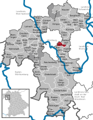
Gerbrunn – miejscowość i gmina w Niemczech, w kraju związkowym Bawaria, w rejencji Dolna Frankonia, w regionie Würzburg, w powiecie Würzburg. Leży około 3 km na wschód od centrum Würzburga, przy drodze B8 i linii kolejowej Monachium - Norymberga - Würzburg. W 2011 liczyła 6 480 mieszkańców.
Demografia
| Rok | Liczba mieszk. |
| 1970 | 4037 |
| 1987 | 5791 |
| 2000 | 6180 |
Współpraca
Miejscowości partnerskie:
Media użyte na tej stronie
|
|
|
|
|
|
|
|
Autor: Philipp M. Moore, Licencja: CC BY 3.0
View of the main valley of Gerbrunn between the Happachberg and the Zottenhügel. The course of the main road winding through the vally is hinted by the houses. The roman catholic church St. Nikolaus is clearly visible. Some of the Julius-Maximilians-Universität Würzburg's buildings (Hubland campus) can be made out in the center of the Picture at the end of the build-up area. In the background one can see the Frankenwarte and the radio towers on the Nikolausberg near Wuerzburg.


