Gers
| Departament | |||||
 | |||||
| Państwo | |||||
|---|---|---|---|---|---|
| Region | |||||
| Prefektura | |||||
| Kod ISO 3166-2 | FR-32 | ||||
| Powierzchnia | 6257 km² | ||||
| Populacja (2010[1]) • liczba ludności |
| ||||
| • gęstość | 30 os./km² | ||||
| Szczegółowy podział administracyjny | |||||
| Liczba podprefektur | 2 | ||||
| Liczba kantonów | 31 | ||||
| Liczba gmin | 463 | ||||
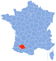
Położenie na mapie | |||||
| Portal | |||||
Gers [ʒɛːʀ lub ʒɛʀs] – francuski departament położony w regionie Oksytania. Utworzony został podczas rewolucji francuskiej 4 marca 1790. Departament oznaczony jest liczbą 32. Jego nazwa pochodzi od nazwy rzeki Gers.
Według danych na rok 2010 liczba zamieszkującej departament ludności wynosi 188 159 os. (30 os./km²); powierzchnia departamentu to 6257 km². Prefekturą departamentu Gers jest miasto Auch.
Prezydentem departamentu jest Jean-Pierre Pujol.
Liczba gmin w departamencie: 463
Zobacz też
- podział administracyjny Francji
- regiony i departamenty Francji
- gminy departamentu Gers
Przypisy
- ↑ INSEE: Populations légales 2010 pour les départements et les collectivités d'outre-mer (fr.). [dostęp 2013-09-07].
Media użyte na tej stronie
Autor: MOSSOT, Licencja: CC BY-SA 3.0
Auch - Prefecture du Gers, ancien Palais archiépiscopal
Autor: Heralder, Licencja: CC BY-SA 3.0
Arms of the French Region of Languedoc-Roussillon
Autor: Diades, Licencja: CC BY-SA 3.0
The flag of department of Gers. The lion is from the blason by Syryatsu in the file "Blason département fr Gers.svg"
Blason (non-officiel attendu que ce département ne revendique pas de blason) du département du Gers : d’argent au lion de gueules.
Également blason de Erquéry (Oise, France).
Autor: Marmelad, Licencja: CC BY-SA 2.5
Autogenerated image to indicate departement given by filename.


