Gifu
| |||||||
| |||||||
 | |||||||
| Państwo | |||||||
| Prefektura | Gifu | ||||||
| Wyspa | Honsiu | ||||||
| Region | Chūbu | ||||||
| Burmistrz | Masanao Shibahashi | ||||||
| Powierzchnia | 203,60 km² | ||||||
| Populacja (1 IX 2018[1]) • liczba ludności • gęstość | 410 252 2 015 os./km² | ||||||
| Nr kierunkowy | (+81) 58 | ||||||
| Kod pocztowy | 500-8701 | ||||||
| Symbole japońskie | |||||||
| Drzewo | Castanopsis cuspidata | ||||||
| Kwiat | Szałwia błyszcząca | ||||||
| Strona internetowa | |||||||
| Portal | |||||||
Gifu (jap. 岐阜市 Gifu-shi) – miasto w Japonii, ośrodek administracyjny prefektury Gifu, na wyspie Honsiu, na północ od Nagoi[2].
Położenie
Miasto leży niemal w centrum Japonii, około 250 km na zachód od Tokio i 140 km na wschód od Osaki. Położone jest w północnej części równiny Nōbi, przez którą przepływają rzeki: Nagara, Kiso, Ibi (zwane łącznie: „trzema rzekami Kiso”, gdyż w swoim dolnym biegu na przemian łączą się i rozdzielają).
Najwyższym szczytem, usytuowanym w środku miasta, jest wzgórze Kinka (dawniej Inaba) o wysokości 329 m n.p.m.
Gospodarka
W mieście rozwinął się przemysł włókienniczy, chemiczny, maszynowy, lotniczy, papierniczy, szklarski oraz rzemieślniczy[3].
Miasta partnerskie
 Florencja, Włochy
 Hangzhou, Chińska Republika Ludowa
 Campinas, Brazylia
 Cincinnati, Stany Zjednoczone
 Meidling, Austria
 Thunder Bay, Kanada
Galeria
Zobacz też
- Oficjalna strona miasta (ang.)
- Tramwaje w Gifu
- Informacja o zamku (ang.)
Przypisy
- ↑ The location of the city, the area and the population (ang.). Gifu City Office. [dostęp 2018-09-17].
- ↑ 日本地図 (Nihon Chizu). Tokyo: Seibido Shuppan, 2018, s. 185. ISBN 978-4-415-11272-5.
- ↑ Gifu, [w:] Encyklopedia PWN [online] [dostęp 2021-07-03].
Media użyte na tej stronie
Autor: Maximilian Dörrbecker (Chumwa), Licencja: CC BY-SA 3.0
Location map of Japan
Equirectangular projection.
Geographic limits to locate objects in the main map with the main islands:
- N: 45°51'37" N (45.86°N)
- S: 30°01'13" N (30.02°N)
- W: 128°14'24" E (128.24°E)
- E: 149°16'13" E (149.27°E)
Geographic limits to locate objects in the side map with the Ryukyu Islands:
- N: 39°32'25" N (39.54°N)
- S: 23°42'36" N (23.71°N)
- W: 110°25'49" E (110.43°E)
- E: 131°26'25" E (131.44°E)
The flag of Navassa Island is simply the United States flag. It does not have a "local" flag or "unofficial" flag; it is an uninhabited island. The version with a profile view was based on Flags of the World and as a fictional design has no status warranting a place on any Wiki. It was made up by a random person with no connection to the island, it has never flown on the island, and it has never received any sort of recognition or validation by any authority. The person quoted on that page has no authority to bestow a flag, "unofficial" or otherwise, on the island.
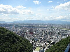
A panorama view of Gifu City
金華山
Emblem of Gifu, Gifu
Flag of Gifu, Gifu
Autor: Alpsdake, Licencja: CC BY-SA 4.0
Gifu City Tower 43 and Gifu Sky Wing 37 from Twinarch138 and Gifu Sky Wing 37 seen from Twinarch138 in Gifu prefecture, Japan.


