Glasson Dock
| ||
 | ||
| Państwo | ||
| Kraj | ||
| Hrabstwo | Lancashire | |
| Dystrykt | Lancaster | |
| Nr kierunkowy | 01524 | |
| Kod pocztowy | LA2 | |
Położenie na mapie Lancashire  Contains Ordnance Survey data © Crown copyright and database right, CC BY-SA 3.0 | ||
Położenie na mapie Wielkiej Brytanii  (c) Karte: NordNordWest, Lizenz: Creative Commons by-sa-3.0 de | ||
Położenie na mapie Anglii  | ||
| Strona internetowa | ||
| Portal | ||
Glasson Dock – wieś w Anglii, w hrabstwie Lancashire, w dystrykcie Lancaster. Leży 72 km na północny zachód od miasta Manchester i 332 km na północny zachód od Londynu[1].
 (c) robert wade, CC BY-SA 2.0
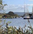 (c) Don Burgess, CC BY-SA 2.0

Przypisy
- ↑ Glasson Dock na mapie (ang.). getamap.ordnancesurvey.co.uk. [dostęp 2010-10-06].
Media użyte na tej stronie
Lancashire UK location map.svg
Contains Ordnance Survey data © Crown copyright and database right, CC BY-SA 3.0
Contains Ordnance Survey data © Crown copyright and database right, CC BY-SA 3.0
Map of Lancashire, UK with the following information shown:
- Administrative borders
- Coastline, lakes and rivers
- Roads and railways
- Urban areas
Equirectangular map projection on WGS 84 datum, with N/S stretched 165%
Geographic limits:
- West: 3.13W
- East: 2.03W
- North: 54.25N
- South: 53.47N
United Kingdom adm location map.svg
(c) Karte: NordNordWest, Lizenz: Creative Commons by-sa-3.0 de
Location map of the United Kingdom
(c) Karte: NordNordWest, Lizenz: Creative Commons by-sa-3.0 de
Location map of the United Kingdom


Flag of England.svg
Flag of England. Saint George's cross (a red cross on a white background), used as the Flag of England, the Italian city of Genoa and various other places.
Flag of England. Saint George's cross (a red cross on a white background), used as the Flag of England, the Italian city of Genoa and various other places.

Glasson Dock - geograph.org.uk - 607729.jpg
(c) Don Burgess, CC BY-SA 2.0
Glasson Dock Looking along the Lancaster Canal Branch from the Basin
(c) Don Burgess, CC BY-SA 2.0
Glasson Dock Looking along the Lancaster Canal Branch from the Basin

Glasson Dock.JPG
Autor: Antiquary, Licencja: CC BY 4.0
The dock at Glasson Dock, Lancashire, seen from the east.
Autor: Antiquary, Licencja: CC BY 4.0
The dock at Glasson Dock, Lancashire, seen from the east.

Christ Church, Glasson Dock.jpg
Autor: Antiquary, Licencja: CC BY 4.0
Christ Church, Glasson, Lancashire, seen from the southwest
Autor: Antiquary, Licencja: CC BY 4.0
Christ Church, Glasson, Lancashire, seen from the southwest

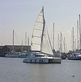
Canal Basin at Glasson Dock - geograph.org.uk - 1484181.jpg
(c) robert wade, CC BY-SA 2.0
Canal Basin at Glasson Dock This basin is not tidal
(c) robert wade, CC BY-SA 2.0
Canal Basin at Glasson Dock This basin is not tidal