Glendora (Kalifornia)
 | |
| Państwo | |
|---|---|
| Stan | |
| Hrabstwo | |
| Prawa miejskie | 13 listopada 1911[1] |
| Burmistrz | Gene Murabito[2] |
| Powierzchnia | 50,655[3] km² |
| Wysokość | 236[1] m n.p.m. |
| Populacja (2010) • liczba ludności • gęstość |
|
| Nr kierunkowy | 626 |
| Kod pocztowy | 91740–91741 |
| 34°07′51″N 117°51′15″W/34,130833 -117,854167 | |
| Strona internetowa | |
| Portal | |
Glendora – miasto w Stanach Zjednoczonych, w stanie Kalifornia, w hrabstwie Los Angeles. W 2010 zamieszkiwało je 50 073 osób[3]. Miasto leży na wysokości 236 metrów n.p.m. i zajmuje powierzchnię 50,655 km²[1].
Prawa miejskie uzyskało 13 listopada 1911[1].
Przypisy
- ↑ a b c d Feature Detail Report for: Glendora (ang.). Geographic Names Information System. [dostęp 2017-03-04].
- ↑ Gene Murabito 9 Mayor (ang.). ci.glendora.ca.us. [dostęp 2017-03-04].
- ↑ a b c 2010 place list. United States Census. [dostęp 2017-03-04].
Linki zewnętrzne
- Strona internetowa miasta. [dostęp 2017-03-04].
Media użyte na tej stronie
Autor: NordNordWest, Licencja: CC BY 3.0
Location map of California, USA
Autor: Uwe Dedering, Licencja: CC BY-SA 3.0
Location map of the USA (without Hawaii and Alaska).
EquiDistantConicProjection:
Central parallel:
* N: 37.0° N
Central meridian:
* E: 96.0° W
Standard parallels:
* 1: 32.0° N
* 2: 42.0° N
Made with Natural Earth. Free vector and raster map data @ naturalearthdata.com.
Formulas for x and y:
x = 50.0 + 124.03149777329222 * ((1.9694462586094064-({{{2}}}* pi / 180))
      * sin(0.6010514667026994 * ({{{3}}} + 96) * pi / 180))
y = 50.0 + 1.6155950752393982 * 124.03149777329222 * 0.02613325650382181
      - 1.6155950752393982  * 124.03149777329222 *
     (1.3236744353715044  - (1.9694462586094064-({{{2}}}* pi / 180))
      * cos(0.6010514667026994 * ({{{3}}} + 96) * pi / 180))
The flag of Navassa Island is simply the United States flag. It does not have a "local" flag or "unofficial" flag; it is an uninhabited island. The version with a profile view was based on Flags of the World and as a fictional design has no status warranting a place on any Wiki. It was made up by a random person with no connection to the island, it has never flown on the island, and it has never received any sort of recognition or validation by any authority. The person quoted on that page has no authority to bestow a flag, "unofficial" or otherwise, on the island.
Flag of California. This version is designed to accurately depict the standard print of the bear as well as adhere to the official flag code regarding the size, position and proportion of the bear, the colors of the flag, and the position and size of the star.
Autor: InSapphoWeTrust from Los Angeles, California, USA, Licencja: CC BY-SA 2.0
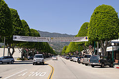
Looking north from Civic Center along Glendora Avenue, which is the historical shopping area that still is home to mom-and-pop stores.
I am paying a visit to Glendora, located along the old Route 66 at the eastern edge of San Gabriel Valley, during its Earth Day festival.
While San Gabriel Valley as a whole has gone through growth and demographic changes over the years, Glendora has retained the feel of San Gabriel Valley of yore; its population is smaller, its historic town core remains vibrant, and it is also a rare San Gabriel Valley city that remains majority white.
My favorite singer-songwriter Anna Nalick grew up here in Glendora. And part of my Glendora visit is to soak up the same influences and vibes that had inspired Anna's songwriting. Following the vibes that have inspired my favorite musicians will now be a new twist to my future travels; in fact my Glendora visit is sort of a practice run for my visit to Huntington, Long Island, New York, just over a week later - where my longtime idol Mariah Carey grew up.


