Gloucester Road
| ||
 Budynek stacji | ||
| Państwo | ||
| Kraj | ||
| Miejscowość | Londyn | |
| Data otwarcia | 1868 | |
| District Line | ||
| Poprzednia stacja | Earl’s Court | |
| Następna stacja | South Kensington | |
| Circle Line | ||
| Poprzednia stacja | Edgware Road | |
| Następna stacja | Great Portland Street | |
| Piccadilly line | ||
| Poprzednia stacja | South Kensington | |
| Następna stacja | Earl’s Court | |
Położenie na mapie gminy Kensington and Chelsea  Contains Ordnance Survey data © Crown copyright and database right, CC BY-SA 3.0 | ||
Położenie na mapie Wielkiej Brytanii  (c) Karte: NordNordWest, Lizenz: Creative Commons by-sa-3.0 de | ||
Położenie na mapie Anglii  | ||
Położenie na mapie Wielkiego Londynu  Contains Ordnance Survey data © Crown copyright and database right, CC BY-SA 3.0 | ||
| Portal | ||
Gloucester Road – stacja metra londyńskiego na terenie Royal Borough of Kensington and Chelsea, leżąca na trasie trzech linii: District Line, Circle Line i Piccadilly line[1]. Powstała w 1868 roku[2]. W roku 2009 skorzystało z niej ok. 13,734 mln pasażerów[3]. Należy do pierwszej strefy biletowej[4].
Galeria

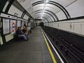
Wspólne perony Circle i District Line
Jeden z dwóch peronów linii Piccadilly

Logo stacji

Budynek stacji od strony wejścia na perony linii Piccadilly
Przypisy
- ↑ Schemat sieci metra londyńskiego [dostęp 2010-12-17]
- ↑ CULG – District Line. [dostęp 2010-12-17].
- ↑ Tube performance | Transport for London. [dostęp 2010-12-17].
- ↑ Lista stacji i stref biletowych metra londyńskiego [dostęp 2010-12-17]
| |||||||||||
| |||||||||||||||||||||
| |||||||||||||
Media użyte na tej stronie
(c) Karte: NordNordWest, Lizenz: Creative Commons by-sa-3.0 de
Location map of the United Kingdom
Contains Ordnance Survey data © Crown copyright and database right, CC BY-SA 3.0
Map of Greater London, UK with the following information shown:
- Administrative borders
- Coastline, lakes and rivers
- Roads and railways
- Urban areas
The data includes both primary routes and railway lines.
Equirectangular map projection on WGS 84 datum, with N/S stretched 160%
Geographic limits:
- West: 0.57W
- East: 0.37E
- North: 51.72N
- South: 51.25N

Blue Shield - the Distinctive emblem for the Protection of Cultural Property. The distinctive emblem is a protective symbol used during armed conflicts. Its use is restricted under international law.


Flag of England. Saint George's cross (a red cross on a white background), used as the Flag of England, the Italian city of Genoa and various other places.

Autor: Sunil060902, Licencja: CC BY-SA 3.0
Gloucester Road tube station Piccadilly line eastbound platform looking west


Autor: Sunil060902, Licencja: CC BY-SA 3.0
Gloucester Road tube station westbound (ie. clockwise) Circle line platform looking east. District line westbound services have their own platform to the right.
Contains Ordnance Survey data © Crown copyright and database right, CC BY-SA 3.0
Blank map of the Royal Borough of Kensington and Chelsea, showing electoral wards.
Equirectangular map projection on WGS 84 datum, with N/S stretched 160%
Geographic limits:
- West: 0.235W
- East: 0.145W
- North: 51.535N
- South: 51.475N


Autor: Sunil060902, Licencja: CC BY-SA 3.0
Gloucester Road tube station District and Circle line platform roundel
