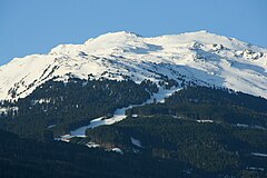
Glungezer
| ||
 | ||
| Państwo | ||
| Położenie | Tyrol | |
| Pasmo | Tuxer Alpen | |
| Wysokość | 2677 m n.p.m. | |
Glungezer – szczyt w grupie górskiej Tuxer Alpen, w Alpach Wschodnich. Leży w Austrii, w kraju związkowym Tyrol. Leży na wschód od Patscherkofel, na północ od Rosenjoch i na południowy wschód od Innsbrucku. Pod szczytem, na wysokości 2610 m, znajduje się schronisko Glungezerhütte.
Bibliografia
- Rainer Brandner u.a.: Überblick zu den Ergebnissen der geologischen Vorerkundung für den Brenner-Basistunnel in Geo.Alp, Vol. 5, S. 165–174, Innsbruck 2008.
Media użyte na tej stronie
Black up-pointing triangle ▲, U+25B2 from Unicode-Block Geometric Shapes (25A0–25FF)
The Glungezer seen from Baumkirchen


