Gmina Keila
| |||||
| Gmina | |||||
 | |||||
| Państwo | |||||
|---|---|---|---|---|---|
| Siedziba | Keila | ||||
| Powierzchnia | 179 km² | ||||
| Populacja • liczba ludności | 4 714 | ||||
| • gęstość | 22,6 os./km² | ||||
| Kod pocztowy | 76607 | ||||
Położenie na mapie Estonii (c) Karte: NordNordWest, Lizenz: Creative Commons by-sa-3.0 de | |||||
| 59°21′05″N 24°35′56″E/59,351389 24,598889 | |||||
| Portal | |||||
Gmina Keila (est. Keila vald) – gmina wiejska w Estonii, w prowincji Harju.
W skład gminy Keila wchodzą:
- 3 miasteczka: Karjaküla, Klooga, Keila-Joa
- 19 wsi: Illurma, Keelva, Kersalu, Kloogaranna, Kulna, Käesalu, Laoküla, Laulasmaa, Lehola, Lohusalu, Maeru, Meremõisa, Nahkjala, Niitvälja, Ohtu, Põllküla, Tuulna, Tõmmiku, Valkse.
Zobacz też
Linki zewnętrzne
Media użyte na tej stronie
Lahepere laht ja Pakri poolsaar.jpg
Autor: Ivar Leidus, Licencja: CC BY-SA 3.0
Lahepere bay and Pakri peninsula
Autor: Ivar Leidus, Licencja: CC BY-SA 3.0
Lahepere bay and Pakri peninsula
Flag of Keila vald.svg
Flag of Keila Commune
Flag of Keila Commune
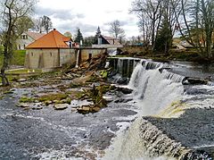
Treppoja 28-05-2013.jpg
Autor: Ivar Leidus, Licencja: CC BY-SA 3.0
Stream Treppoja (direct translation: stairs stream)
Autor: Ivar Leidus, Licencja: CC BY-SA 3.0
Stream Treppoja (direct translation: stairs stream)
Coat of arms of Keila vald.svg
Coat of arms of Keila Commune
Coat of arms of Keila Commune
Tallinna–Paldiski maantee Valkse külas.jpg
Autor: Ivar Leidus, Licencja: CC BY-SA 3.0
Tallinn–Paldiski road in Valkse village
Autor: Ivar Leidus, Licencja: CC BY-SA 3.0
Tallinn–Paldiski road in Valkse village
Estonia adm location map.svg
(c) Karte: NordNordWest, Lizenz: Creative Commons by-sa-3.0 de
Location map of Estonia
(c) Karte: NordNordWest, Lizenz: Creative Commons by-sa-3.0 de
Location map of Estonia


