Gmina Strängnäs
| gmina | |||
 | |||
| |||
| Państwo | |||
|---|---|---|---|
| Region | |||
| Siedziba | |||
| Kod statystyczny | 0486 | ||
| Powierzchnia | 975,08 km² | ||
| Populacja (2013) • liczba ludności |
| ||
| • gęstość | 45,14 os./km² | ||
Położenie na mapie regionu Södermanland | |||
| Strona internetowa | |||
| Portal | |||
Gmina Strängnäs (szw. Strängnäs kommun) – gmina w Szwecji, położona w regionie administracyjnym (län) Södermanland. Siedzibą władz gminy (centralort) jest Strängnäs.
Geografia

Gmina Strängnäs położona jest w prowincji historycznej Södermanland, na południe od jeziora Melar. Gmina Strängnäs graniczy z gminami (w kolejności od kierunku wschodniego):
oraz od północy i północnego wschodu przez jezioro Melar z gminami:
Powierzchnia
Gmina Strängnäs jest 120. pod względem powierzchni z 290 gmin Szwecji. Według danych pochodzących z 2013 r. całkowita powierzchnia gminy wynosi łącznie 975,08 km², z czego:
- 739,7 km² stanowi ląd
- 235,38 km² wody śródlądowe (w tym 220,5 km² wody jeziora Melar)[1].
Demografia
31 grudnia 2013 r. gmina Strängnäs liczyła 33 389 mieszkańców (74. pod względem zaludnienia z 290 gmin Szwecji)[2], gęstość zaludnienia wynosiła 45,14 mieszkańców na km² lądu (99. pod względem gęstości zaludnienia z 290 gmin Szwecji).
Struktura demograficzna (31 grudnia 2013)[3]:
| Opis | Ogółem | Kobiety | Mężczyźni | |||
|---|---|---|---|---|---|---|
| jednostka | osób | % | osób | % | osób | % |
| populacja | 33 389 | 100 | 16 762 | 50,20 | 16 627 | 49,80 |
| powierzchnia | 975,08 km² | |||||
| gęstość zaludnienia (mieszk./km²) | 45,14 | |||||
Miejscowości
Miejscowości (tätort, -er) gminy Strängnäs (2010)[4]:
| # | Miejscowość | Liczba ludności |
|---|---|---|
| 1 | Strängnäs | 12 856 |
| 2 | Mariefred | 3 726 |
| 3 | Åkers styckebruk | 2 891 |
| 4 | Abborrberget | 2 141 |
| 5 | Stallarholmen | 1 623 |
| 6 | Härad | 508 |
| 7 | Marielund | 416 |
| 8 | Merlänna | 356 |
| 9 | Vansö kyrkby | 202 |
Wybory
Wyniki wyborów do rady gminy Strängnäs (kommunfullmäktige) 2010 r.[5]:
| Partia | Liczba głosów | Zmiana liczby głosów | Procent głosów | Zmiana % | Uzyskane mandaty | Zmiana liczby mandatów | |
|---|---|---|---|---|---|---|---|
| Moderaterna | 5601 | +532 | 27,60 | +0,62 | 15 | +2 | |
| Centerpartiet | 2031 | +436 | 10,01 | +1,52 | 6 | +2 | |
| Folkpartiet | 1479 | –279 | 7,29 | –2,07 | 4 | –1 | |
| Chrześcijańscy Demokraci | 748 | –194 | 3,69 | –1,33 | 2 | ±0 | |
| Socialdemokraterna | 5428 | –837 | 26,75 | –6,59 | 15 | –1 | |
| Vänsterpartiet | 722 | +124 | 3,56 | +0,38 | 2 | ±0 | |
| Miljöpartiet | 1165 | +415 | 5,74 | +1,75 | 4 | +2 | |
| Strängnäspartiet | 994 | +212 | 4,90 | +0,74 | 3 | +1 | |
| Sverigedemokraterna | 983 | +656 | 4,84 | +3,10 | 2 | +1 | |
| Mariefredspartiet | 852 | +224 | 4,20 | +0,86 | 2 | ±0 | |
| Pozostałe partie | 288 | +214 | 1,42 | +1,03 | 0 | – | |
| Razem (frekwencja 82,70%) | 20 291 | 100,0 | 55 | +6 | |||
| Źródło: Valmyndigheten (szw.) | |||||||
Współpraca zagraniczna
Miasta partnerskie gminy Strängnäs[6]:
Przypisy
- ↑ Statistiska centralbyrån: Land- och vattenareal per den 1 januari efter region och arealtyp. År 2012 – 2018. [dostęp 2014-05-18]. (szw.).
- ↑ Statistiska centralbyrån: Folkmängd i riket, län och kommuner 31 december 2013 och befolkningsförändringar 1 oktober - 31 december 2013. Totalt. [dostęp 2014-05-18]. (szw.).
- ↑ Statistiska centralbyrån: Folkmängd i riket, län och kommuner efter kön och ålder 31 december 2013. [dostęp 2014-05-18]. (szw.).
- ↑ Statistiska centralbyrån: Tätorter; arealer, befolkning. Tätorter 2010. [dostęp 2014-05-18]. (szw.).
- ↑ Länsstyrelsen i Södermanlands län: Protokoll. Val till kommunfullmäktige 2010-09-19. Kommun: Strängnäs. [dostęp 2014-05-18]. [zarchiwizowane z tego adresu (2014-05-18)]. (szw.).
- ↑ Strängnäs kommun: Nätverk och vänorter. [dostęp 2014-05-18]. [zarchiwizowane z tego adresu (2014-02-21)]. (szw.).
Media użyte na tej stronie
Flaga Finlandii
photo taken and uploaded by purple. Photo taken in August 2005. This picture is released to the public domain
Picture at Akers Krutbruk, in Akers styckebruk, marsh 2009.
(c) Lokal_Profil, CC BY-SA 2.5
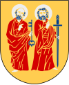
This coat of arms was drawn based on its blazon which – being a written description – is free from copyright. Any illustration conforming with the blazon of the arms is considered to be heraldically correct. Thus several different artistic interpretations of the same coat of arms can exist. The design officially used by the armiger is likely protected by copyright, in which case it cannot be used here.
Individual representations of a coat of arms, drawn from a blazon, may have a copyright belonging to the artist, but are not necessarily derivative works.
Autor: Clemensfranz, Licencja: CC BY 3.0
Schweden, Mariefred, Schloss Gripsholm
Felaktigheter kan även anmälas till denna sida.
Motiv: Strängnäs
Nyckelord: Riksintressen
Autor: user:Nordelch, Licencja: CC BY-SA 1.0
Strängnäs Municipality in Södermanland County
Autor: Marmelad and Lokal_Profil
, Licencja: CC BY-SA 2.5
This coat of arms was drawn based on its blazon which – being a written description – is free from copyright. Any illustration conforming with the blazon of the arms is considered to be heraldically correct. Thus several different artistic interpretations of the same coat of arms can exist. The design officially used by the armiger is likely protected by copyright, in which case it cannot be used here.
Individual representations of a coat of arms, drawn from a blazon, may have a copyright belonging to the artist, but are not necessarily derivative works.
Autor: Lars MS from Oslo, Norway, Licencja: CC BY 2.0
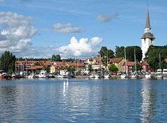
Vy över Strängnäs med väderkvarnen och domkyrkan.


