Gmina Tapa
| |||||
| |||||
 | |||||
| Państwo | |||||
| Prowincja | Virumaa Zachodnia | ||||
| Siedziba | Tapa | ||||
| Powierzchnia | 480 km² | ||||
| Populacja (2018) • liczba ludności | 11049 | ||||
| • gęstość | 35,9 os./km² | ||||
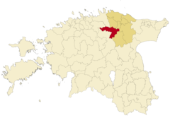
Położenie na mapie | |||||
| Strona internetowa | |||||
| Portal | |||||
Gmina Tapa (est. Tapa vald) – gmina wiejska w Estonii, w prowincji Virumaa Zachodnia.
Skład gminy[1]:
- Miasto: Tapa, Tamsalu.
- Alevik: Lehtse, Sääse.
- Wieś: Aavere, Alupere, Araski, Assamalla, Imastu, Jootme, Jäneda, Järsi, Järvajõe, Kadapiku, Kaeva, Karkuse, Kerguta, Koiduküla, Koplitaguse, Kuie, Kullenga, Kursi, Kuru, Kõrveküla, Lemmküla, Linnape, Loksa, Loksu, Lokuta, Läpi, Läste, Metskaevu, Moe, Naistevälja, Nõmmküla, Näo, Patika, Piilu, Piisupi, Porkuni, Pruuna, Põdrangu, Rabasaare, Raudla, Rägavere, Räsna, Saiakopli, Saksi, Sauvälja, Savalduma, Tõõrakõrve, Türje, Uudeküla, Vadiküla, Vahakulmu, Vajangu, Vistla, Võhmetu, Võhmuta.
Miasta partnerskie
 Trosa
Trosa Akaa
Akaa Pyhäntä
 Siikajoki
 Siikalatva
 Hohenfelde
 Preetz
 Cumberland
Przypisy
- ↑ Statistics Estonia, Classification of Estonian administrative units and settlements 2018v3, 19 stycznia 2019 (ang.).
Media użyte na tej stronie
Flag of Finland.svg
Flaga Finlandii
Flaga Finlandii
Flag of the United States.svg
The flag of Navassa Island is simply the United States flag. It does not have a "local" flag or "unofficial" flag; it is an uninhabited island. The version with a profile view was based on Flags of the World and as a fictional design has no status warranting a place on any Wiki. It was made up by a random person with no connection to the island, it has never flown on the island, and it has never received any sort of recognition or validation by any authority. The person quoted on that page has no authority to bestow a flag, "unofficial" or otherwise, on the island.
The flag of Navassa Island is simply the United States flag. It does not have a "local" flag or "unofficial" flag; it is an uninhabited island. The version with a profile view was based on Flags of the World and as a fictional design has no status warranting a place on any Wiki. It was made up by a random person with no connection to the island, it has never flown on the island, and it has never received any sort of recognition or validation by any authority. The person quoted on that page has no authority to bestow a flag, "unofficial" or otherwise, on the island.
Tapa valla vapp.png
Autor: Tapa Vallavalitsus, Licencja: CC0
The Coat of arms of the Tapa Commune (Parish) from 2017, Estonia
Autor: Tapa Vallavalitsus, Licencja: CC0
The Coat of arms of the Tapa Commune (Parish) from 2017, Estonia
Tapa valla lipp.png
Autor: Tapa Vallavalitsus, Licencja: CC0
The Flag of the Tapa Commune (Parish) from 2017.
Autor: Tapa Vallavalitsus, Licencja: CC0
The Flag of the Tapa Commune (Parish) from 2017.
Tapa vald 2017.png
Autor: Flying Saucer, Licencja: CC BY-SA 4.0
Location of Tapa Parish (red) within Lääne-Viru County (dark yellow) after the Administrative Reform of Estonia in 2017.
Autor: Flying Saucer, Licencja: CC BY-SA 4.0
Location of Tapa Parish (red) within Lääne-Viru County (dark yellow) after the Administrative Reform of Estonia in 2017.


