Godalming
| ||
(c) Humphrey Bolton, CC BY-SA 2.0 Kościół parafialny w Godalmingu | ||
| Państwo | ||
| Kraj | ||
| Hrabstwo | Surrey | |
| Populacja • liczba ludności | 21 103 | |
| Nr kierunkowy | 01483 | |
| Kod pocztowy | GU7 | |
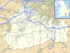
Położenie na mapie Surrey Contains Ordnance Survey data © Crown copyright and database right, CC BY-SA 3.0 | ||
| Strona internetowa | ||
| Portal | ||
Godalming – miasto w Wielkiej Brytanii, w Anglii, w hrabstwie Surrey.
Jest to od wieków miasto targowe, rozłożone nad brzegami rzeki Wey w pagórkowatej, gęsto zalesionej otulinie Londynu (oddalone ok. 49 km). Stoi tu stary murowany kościół. W mieście działa od XVII wieku szkoła Charterhouse, z siedzibą w zespole poklasztornym. Do szkoły tej uczęszczali członkowie-założyciele grupy rockowej Genesis.
W mieście ma swą siedzibę klub piłkarski - Godalming Town F.C.
- (c) Colin Smith, CC BY-SA 2.0
ulica Kościelna - stary dom szachulcowy
- (c) Stephen Nunney, CC BY-SA 2.0
Domek na wodzie w Winkworth Arboretum
Miasta partnerskie
Media użyte na tej stronie
Autor: NordNordWest, Licencja: CC BY-SA 3.0
Location map of the United Kingdom
Flag of England. Saint George's cross (a red cross on a white background), used as the Flag of England, the Italian city of Genoa and various other places.
(c) Stephen Nunney, CC BY-SA 2.0
Boathouse at Winkworth Arboretum.
Autor: Hassocks5489, Licencja: CC0
Former Godalming Congregational Church, Bridge Road, Godalming, Borough of Waverley, Surrey, England. Now a restaurant.
Autor: Birdy10, Licencja: CC BY-SA 3.0
Flamingo's aan bat tegen Free Foresters - Charterhouse School, 1 augustus 2006
(c) Colin Smith, CC BY-SA 2.0
Church Street Old half-timbered, jettied buildings in central Godalming - seen from beneath the arcaded Pepperpot.
Contains Ordnance Survey data © Crown copyright and database right, CC BY-SA 3.0
Map of Surrey, UK with the following information shown:
- Administrative borders
- Coastline, lakes and rivers
- Roads and railways
- Urban areas
Equirectangular map projection on WGS 84 datum, with N/S stretched 160%
Geographic limits:
- West: 0.87W
- East: 0.08E
- North: 51.50N
- South: 51.05N
(c) Humphrey Bolton, CC BY-SA 2.0
Church of St Peter and St Paul, Godalming. There are fragments of Saxon work, and the Normans built the central tower, on which is a lead spire of (probably) the 13C. This has a number of shallow V-sections formed from lead plates. The range of buildings in front of the tower are the south aisle, transept and south chapel, all added in the 12C and 13C. The church was extensively restored in the 19C.


