Goes (gmina)
| Gmina | |||||
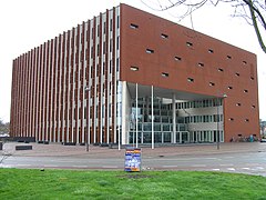
 Siedziba gminy w Goes | |||||
| |||||
| Państwo | |||||
|---|---|---|---|---|---|
| Prowincja | |||||
| Siedziba | |||||
| Burmistrz | René Verhulst | ||||
| Powierzchnia | 101,92 km² | ||||
| Populacja (2016) • liczba ludności |
| ||||
| • gęstość | 401 os./km² | ||||
| Numer kierunkowy | 0113 | ||||
| Kod pocztowy | 4460-4483 | ||||
Adres urzędu: M.A. de Ruijterlaan 2, Goes | |||||
| Plan | |||||
 | |||||
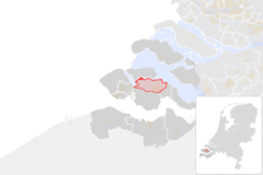
Położenie na mapie | |||||
| Strona internetowa | |||||
Goes – gmina w Holandii, w prowincji Zelandia. Siedzibą gminy jest Goes. Według spisu ludności z roku 2016 gminę zamieszkuje 37 260 osób[1]. Burmistrzem od 2010 roku jest René Verhulst[2]. Przez gminę przebiegają autostrady A58 i A256. Na jej terenie mieści się stacja kolejowa Goes.
Miejscowości
Na terenie gminy znajduje się 9 miejscowości, w tym 1 miasto (Goes), a także 11 przysiółków.
| Miejscowość | l. ludności (2010 r.) |
|---|---|
| Goes | 27 157 |
| Kloetinge | 3348 |
| Wolphaartsdijk | 2068 |
| 's-Heer Hendrikskinderen | 1362 |
| 's-Heer Arendskerke | 1281 |
| Wilhelminadorp | 753 |
| Kattendijke | 553 |
| Oud-Sabbinge | 234 |
| Eindewege | 218 |
Przysiółki: Blauwewijk, De Groe, Goese Sas, Monnikendijk, Noordeinde, Planketent, Roodewijk, Sluis de Piet, Tervaten, Waanskinderen, Wissekerke
Przypisy
- ↑ Bevolkingsontwikkeling; regio per maand (niderl.). statline.cbs.nl. [dostęp 2016-01-02].
- ↑ Herbenoeming burgemeester René Verhulst (niderl.). goes.nl. [dostęp 2016-01-02]. [zarchiwizowane z tego adresu (2017-01-03)].
Bibliografia
- Wetenswaardigheden, cijfers en statistieken over de gemeente Goes (niderl.). oozo.nl. [dostęp 2016-01-02].
Media użyte na tej stronie
Autor:
Michiel1972 using data from CBS.
 |
Właściciel autorskich praw majątkowych do tego pliku, Centraal Bureau voor de Statistiek, zezwala każdemu wykorzystać go w dowolnym celu, pod warunkiem, że wykorzystujący wyraźnie wskaże autora. Redystrybucja, wykonywanie prac pochodnych, użycie komercyjne oraz każde inne są dozwolone. |
Uznanie autorstwa:
Bron: © 2015, Centraal Bureau voor de Statistiek / Topografische Dienst Kadaster
|
Locator map showing municipality boundary of one of the 390 Dutch municipalities (as of 2016)
Autor: Janwillemvanaalst, Licencja: CC BY-SA 4.0
Topografische gemeentekaart. Resolutie: 400 pixels/km.
Kaartbeeld samengesteld uit de open geodata van de Top10NL en Top25namen (Kadaster), Creative Commons-BY licentie. Gebouwvlakken uit open geodata BAG extract. Wegen uit de OpenStreetMap, OpenStreetMap community. Reliëfschaduw uit de Actuele Hoogtekaart AHN2.
Samenstelling en kleurenschema: Jan-Willem van Aalst, met QGIS. Zie ook de Legenda.Flag of the Dutch municipality of Goes.
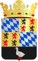
Coat of arms of the Dutch municipality of Goes.


