Gondreville (Meurthe i Mozela)
| miejscowość i gmina | |||
| |||
| Państwo | |||
|---|---|---|---|
| Region | |||
| Departament | |||
| Okręg | |||
| Kod INSEE | 54232 | ||
| Powierzchnia | 24,94 km² | ||
| Populacja (1990) • liczba ludności |
| ||
| • gęstość | 86 os./km² | ||
| Kod pocztowy | 54840 | ||
Położenie na mapie Meurthe i Mozeli  | |||
Położenie na mapie Francji  | |||
Położenie na mapie regionu Grand Est  | |||
| Strona internetowa | |||
| Portal | |||
Gondreville – miejscowość i gmina we Francji, w regionie Grand Est, w departamencie Meurthe i Mozela.
Według danych na rok 1990 gminę zamieszkiwało 2145 osób, a gęstość zaludnienia wynosiła 86 osób/km² (wśród 2335 gmin Lotaryngii Gondreville plasuje się na 197. miejscu pod względem liczby ludności, natomiast pod względem powierzchni na miejscu 103.).
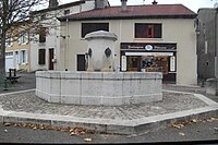
Plac z fontanną w Gondreville (2010)

Gondreville (2014)
Populacja

Populacja Gondreville w latach 1962–2008
Bibliografia
- Francuski urząd statystyczny (fr.).
Linki zewnętrzne
Media użyte na tej stronie
Meurthe-et-Moselle department location map.svg
Autor: Flappiefh, Licencja: CC BY-SA 4.0
Blank administrative map of the department of Meurthe-et-Moselle, France, for geo-location purpose.
Autor: Flappiefh, Licencja: CC BY-SA 4.0
Blank administrative map of the department of Meurthe-et-Moselle, France, for geo-location purpose.
France location map-Regions and departements-2016.svg
Autor: Superbenjamin, Licencja: CC BY-SA 4.0
Blank administrative map of France for geo-location purpose, with regions and departements distinguished. Approximate scale : 1:3,000,000
Autor: Superbenjamin, Licencja: CC BY-SA 4.0
Blank administrative map of France for geo-location purpose, with regions and departements distinguished. Approximate scale : 1:3,000,000
Grand Est region location map.svg
Autor: Flappiefh, Licencja: CC BY-SA 4.0
Carte administrative vierge de la région Grand Est, France, destinée à la géolocalisation.
Autor: Flappiefh, Licencja: CC BY-SA 4.0
Carte administrative vierge de la région Grand Est, France, destinée à la géolocalisation.
.svg)


Gondreville 066.JPG
Autor: Gérald Garitan, Licencja: CC BY-SA 3.0
place de la fontaine de Gondreville.
Autor: Gérald Garitan, Licencja: CC BY-SA 3.0
place de la fontaine de Gondreville.
Population - Municipality code 54232.svg
Autor: Michiel1972, Licencja: CC BY-SA 3.0
Autor: Michiel1972, Licencja: CC BY-SA 3.0
Population - Municipality code 54232.svg
Population Census 1962-2008