Gornja Trepča (Serbia)
| ||
 | ||
| Państwo | ||
|---|---|---|
| Okręg | morawicki | |
| Miasto | Čačak | |
| Populacja (2011) • liczba ludności | 556[1] | |
| Kod pocztowy | 32215 | |
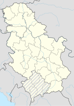
Położenie na mapie Serbii (c) Karte: NordNordWest, Lizenz: Creative Commons by-sa-3.0 de | ||
| 43°57′N 20°29′E/43,950000 20,483333 | ||
Gornja Trepča (cyr. Горња Трепча) – wieś w Serbii, w okręgu morawickim, w mieście Čačak. W 2011 roku liczyła 556 mieszkańców[1].
Przypisy
- ↑ a b Popis stanovništva, domaćinstava i stanova 2011. u Republici Srbiji (serb.). Republički zavod za statistiku. [dostęp 2019-08-29].
Media użyte na tej stronie
Serbia adm location map.svg
(c) Karte: NordNordWest, Lizenz: Creative Commons by-sa-3.0 de
Location map of Serbia
(c) Karte: NordNordWest, Lizenz: Creative Commons by-sa-3.0 de
Location map of Serbia
Gornja Trepca Spa in Serbia 5260 11.jpg
Autor: Zcvetkovic, Licencja: CC BY-SA 4.0
Panoramic scenes of the Pester plateau, karst region in southwestern Serbia. It situated in the area of Raska. The most part of Pešter is located in the municipality of Sjenica. The relief of Pester Plateau is characterized by low, hilly terrain, streams
Autor: Zcvetkovic, Licencja: CC BY-SA 4.0
Panoramic scenes of the Pester plateau, karst region in southwestern Serbia. It situated in the area of Raska. The most part of Pešter is located in the municipality of Sjenica. The relief of Pester Plateau is characterized by low, hilly terrain, streams
Cacak grb.png
Coat of arms of Čačak, Serbia.
Coat of arms of Čačak, Serbia.


