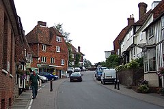
Goudhurst
(c) Ron Strutt, CC BY-SA 2.0 | |
| Państwo | |
|---|---|
| Kraj | |
| Region | South East |
| Hrabstwo | Kent |
| Populacja (2001) • liczba ludności | 3 204 |
| Nr kierunkowy | 01580 |
| Kod pocztowy | TN17 |
Położenie na mapie Kentu Contains Ordnance Survey data © Crown copyright and database right, CC BY-SA 3.0 | |
Położenie na mapie Wielkiej Brytanii (c) Karte: NordNordWest, Lizenz: Creative Commons by-sa-3.0 de | |
| Strona internetowa | |
| Portal | |
Goudhurst - wieś w Anglii w regionie Royal Tunbridge Wells w hrabstwie Kent. Nazwa miejscowości najprawdopodobniej pochodzi od staroangielskiego zwrotu guo hyrst oznaczającego wzgórze bitwy.
Linki zewnętrzne
Media użyte na tej stronie
(c) Karte: NordNordWest, Lizenz: Creative Commons by-sa-3.0 de
Location map of the United Kingdom
Flag of England. Saint George's cross (a red cross on a white background), used as the Flag of England, the Italian city of Genoa and various other places.
(c) Ron Strutt, CC BY-SA 2.0
Goudhurst, Kent. The picturesque Wealden village of Goudhurst wasn't always so peaceful. Smuggling was rife in the area in the 19th century and the business had none of the roguish charm with which it has since been endowed. The Hawkhurst Gang was one of the largest and operated throughout Kent, Hampshire and even Dorset. They were also very violent, threatened those who opposed them, and terrorised the neighbourhood. Eventually the villagers of Goudhurst set up their own Militia, trained by a former soldier, to deal with the problem, whereupon the smugglers threatened to attack the village, kill the residents, and burn the place to the ground. But when the smugglers attacked, it was they who were defeated, three of their number being killed including the gang leader's brother.
Contains Ordnance Survey data © Crown copyright and database right, CC BY-SA 3.0
Map of Kent, UK with the following information shown:
- Administrative borders
- Coastline, lakes and rivers
- Roads and railways
- Urban areas
Equirectangular map projection on WGS 84 datum, with N/S stretched 160%
Geographic limits:
- West: 0.01E
- East: 1.47E
- North: 51.52N
- South: 50.88N


