Gräfenberg
 | |||
| |||
| Państwo | |||
|---|---|---|---|
| Kraj związkowy | Bawaria | ||
| Rejencja | Górna Frankonia | ||
| Powiat | Forchheim | ||
| Powierzchnia | 37,88 km² | ||
| Wysokość | 433 m n.p.m. | ||
| Populacja (31 grudnia 2011) • liczba ludności • gęstość | 4 055 107 os./km² | ||
| Nr kierunkowy | 09192 | ||
| Kod pocztowy | 91322 | ||
| Tablice rejestracyjne | FO, EBS, PEG | ||
Położenie na mapie Bawarii  | |||
Położenie na mapie Niemiec  | |||
| Strona internetowa | |||
| Portal | |||

Gräfenberg – miasto w Niemczech, w kraju związkowym Bawaria, w rejencji Górna Frankonia, w regionie Oberfranken-West, w powiecie Forchheim, siedziba wspólnoty administracyjnej Gräfenberg. Leży ok. 15 km na południowy wschód od Forchheimu, przy drodze B2 i linii kolejowej Gräfenberg – Norymberga.
Podział administracyjny
W skład miasta wchodzą następujące części (Stadtteile):
|
|
Zabytki i atrakcje
- ratusz
- brama miejska
- Kościół pw. św. Michała (St. Michael)
Współpraca
Miejscowości partnerskie:
Galeria

Ratusz
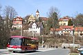
Gräfenberg
Dzielnica Haidhof

Dzielnica Thuisbrunn
Powiat Forchheim (Landkreis Forchheim)
- Siedziba powiatu: Forchheim
| Miasta | |
|---|---|
| Gminy targowe | |
| Gminy | |
| Wspólnoty administracyjne |

Kontrola autorytatywna (gmina miejska w Niemczech):
Media użyte na tej stronie
Bavaria location map G.svg
Autor: Hanhil based upon previous work by TUBS, Licencja: CC BY-SA 3.0
Location map Bavaria, showing position of Bavaria within Germany. Geographic limits of the map:
Autor: Hanhil based upon previous work by TUBS, Licencja: CC BY-SA 3.0
Location map Bavaria, showing position of Bavaria within Germany. Geographic limits of the map:
Germany location map.svg
Autor: NordNordWest, Licencja: CC BY-SA 3.0
Location map of Germany (Wp article: en:Germany)
Autor: NordNordWest, Licencja: CC BY-SA 3.0
Location map of Germany (Wp article: en:Germany)

.svg)


Gräfenberg-altes-Rathaus-Nahaufnahme-16-05-2005.jpeg
Autor: Daniel Arnold, Licencja: CC-BY-SA-3.0
Old baroque town hall in the old town of Gräfenberg (Franconian Swiss mountain range, north Bavaria, Germany) at the central market place. On the left you can see the "Egloffsteiner Tor" gate in the city wall still sourrounding a substantial part of the old town.

Thuisbrunn-Pinselleite-03-07-2005.jpeg
Autor: Daniel Arnold, Licencja: CC-BY-SA-3.0
In the background you can see a mountainside called Pinselleite which is one of the feedlots for sheepherds around the valley where the village of Thuisbrunn is located within (in the Franconian Swiss mountain range in Bavaria, Germany) that are interesting dry biotopes. In the foreground you can see houses of the village of Thuisbrunn. The photo was taken from a place next to the church.

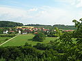
Haidhof-Überblick.jpeg
Autor: Daniel Arnold, Licencja: CC-BY-SA-3.0
The village of Haidhof in the Franconian Swiss mountain range in Bavaria, Germany viewed from above from the peak of the Schlossberg mountain.
Autor: Daniel Arnold, Licencja: CC-BY-SA-3.0
The village of Haidhof in the Franconian Swiss mountain range in Bavaria, Germany viewed from above from the peak of the Schlossberg mountain.