Grójec (stacja kolejowa)
| Państwo | |
|---|---|
| Miejscowość | |
| Data otwarcia | 1917 |
| Data zamknięcia | 2012 |
| Dane techniczne | |
| Liczba peronów | 2 |
| Liczba krawędzi peronowych | 3 |
| Kasy |
|
| Linie kolejowe | |
| |
Położenie na mapie Polski (c) Karte: NordNordWest, Lizenz: Creative Commons by-sa-3.0 de | |
| Portal | |
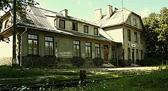
Grójec – nieczynna stacja kolei wąskotorowej w Grójcu, w województwie mazowieckim, w Polsce. Wybudowana w 1915 roku.
Linki zewnętrzne
- Grójec w Ogólnopolskiej Bazie Kolejowej – bazakolejowa.pl
- Grójec w Atlasie Kolejowym Polski, Czech i Słowacji – www.atlaskolejowy.net
| Grójec | ||
| Linia Warszawa Mokotów – Nowe Miasto nad Pilicą (40,460 km) | ||
odległość: 3,65 km | odległość: 3,14 km | |
| Linia Grójec – Jasieniec (0 km) | ||
odległość: 2,5 km | ||
Media użyte na tej stronie
Poland adm location map.svg
(c) Karte: NordNordWest, Lizenz: Creative Commons by-sa-3.0 de
Location map of Poland
(c) Karte: NordNordWest, Lizenz: Creative Commons by-sa-3.0 de
Location map of Poland
Masovian Voivodeship location map.svg
Autor: SANtosito, Licencja: CC BY-SA 4.0
Location map of Masovian Voivodeship. Geographic limits of the map:
Autor: SANtosito, Licencja: CC BY-SA 4.0
Location map of Masovian Voivodeship. Geographic limits of the map:
- N: 53.55N
- S: 50.95 N
- W: 19.15 E
- E: 23.25 E
Powiat grójecki location map.png
Autor:
Mapa powiatu grójeckiego, Polska
Autor:
OpenStreetMap contributors
,
Licencja: CC BY-SA 2.0
Mapa powiatu grójeckiego, Polska
Distinctive emblem for cultural property.svg
Blue Shield - the Distinctive emblem for the Protection of Cultural Property. The distinctive emblem is a protective symbol used during armed conflicts. Its use is restricted under international law.
Blue Shield - the Distinctive emblem for the Protection of Cultural Property. The distinctive emblem is a protective symbol used during armed conflicts. Its use is restricted under international law.
BSicon exKHSTl.svg
ex terminal stop, track to the left
ex terminal stop, track to the left
BSicon exSTRq.svg
Straight line aqross (according to naming convention, name + modifier)
Straight line aqross (according to naming convention, name + modifier)
BSicon exKHSTr.svg
ex terminal stop, track to the right
ex terminal stop, track to the right
BSicon exKBHFl.svg
ex terminal station, track to the left
ex terminal station, track to the left
BSicon exKBHFaq.svg
ex terminal station, track to the left
ex terminal station, track to the left
Grójec (gmina) location map.png
Autor:
Mapa gminy Grójec, Polska
Autor:
OpenStreetMap contributors
,
Licencja: CC BY-SA 2.0
Mapa gminy Grójec, Polska
BSicon exKHSTaq.svg
ex terminal stop, track to the left
ex terminal stop, track to the left
BSicon exBHFq.svg
ex station ex track aqross
ex station ex track aqross
Grójec, Stacja Grójec - fotopolska.eu (241275).jpg
(c) Rafał T / fotopolska.eu, CC BY-SA 3.0
Budynek dworca - widok z torowiska.
(c) Rafał T / fotopolska.eu, CC BY-SA 3.0
Budynek dworca - widok z torowiska.
Grójec location map.svg
Autor:
Mapa miasta Grójec, Polska
Autor:
OpenStreetMap contributors
,
Licencja: CC BY-SA 2.0
Mapa miasta Grójec, Polska
BSicon exKHSTeq.svg
ex terminal stop, track to the right
ex terminal stop, track to the right


