Grand Inga
| ||
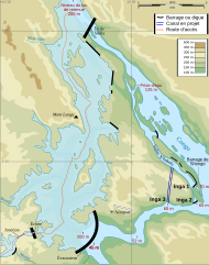
© Sémhur / Wikimedia Commons, CC BY-SA 4.0 Położenie tamy (na dole, pośrodku) na rzece Kongo | ||
| Państwo | ||
| Status | Proponowana/Planowana | |
| Liczba bloków energetycznych | 52 × 750 MW | |
| Moce | ||
| Łączna moc: | ||
| - elektryczna brutto | 39000 MW | |
| Źródła energii | ||
| Źródła energii: | ||
| - główne | woda | |
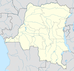
Położenie na mapie Demokratycznej Republiki Konga | ||
Grand Inga – planowana elektrownia wodna na kataraktach Inga na rzece Kongo na terenie Demokratycznej Republiki Konga. Jej budowę, mającą trwać 20 lat i kosztować 100 mld dolarów, zatwierdzono w 2010 r.[1] Elektrownia ma generować moc 39 GW, większą o ponad 70% od mocy największej istniejącej elektrowni wodnej (stan na rok 2015) – Tamy Trzech Przełomów.
Zobacz też
Przypisy
- ↑ Andrzej Hołdys. Wielkie tamy, wielki kłopot. „Wiedza i Życie”. 8 (968), s. 16-21, sierpień 2015. Prószyński Media. ISSN 0137-8929.
Media użyte na tej stronie
The national flag of the Democratic Republic of the Congo. Created according to the 2006 constitution : Son emblème est le drapeau bleu ciel, orné d’une étoile jaune dans le coin supérieur gauche et traversé en biais d’une bande rouge finement encadrée de jaune. (Its symbol is a sky blue flag, decorated with a yellow star in the upper left corner and crossed in the diagonal by a red strip with thin yellow borders) It seems to be identical, except for a lighter field hue, to the 1966–1971 flag.
© Sémhur / Wikimedia Commons, CC BY-SA 4.0
Emphythéose Moanda project, Inga Dam, project situation.
en:SVG logo of a stylized en:lightning bolt on a en:circle. This was designed by me, en:User:Crotalus horridus, as a public domain image that could be used on en:Template:User Metroid. It is similar in style to the screw attack power up.
(c) Uwe Dedering z niemieckiej Wikipedii, CC BY 3.0
Location map of Democratic Republic of the Congo
Equirectangular projection. Strechted by 100.0%. Geographic limits of the map:
- N: 6.0° N
- S: -14.0° N
- W: 11.0° E
- E: 32.0° E
Made with Natural Earth. Free vector and raster map data @ naturalearthdata.com.
A new map with the 26 provinces (since 2015) is available here.


