Grand Palais
 | |
| Państwo | |
|---|---|
| Region | |
| Miejscowość | |
| Typ budynku | hala wystawowa |
| Styl architektoniczny | |
| Ukończenie budowy | |
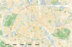
Położenie na mapie Paryża (c) Eric Gaba, Wikimedia Commons user Sting, CC BY-SA 3.0 | |
Położenie na mapie Île-de-France (c) Eric Gaba, Wikimedia Commons user Sting, CC BY-SA 3.0 | |
| Strona internetowa | |
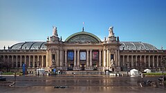
Grand Palais (Wielki Pałac) – duża, przeszklona hala wystawowa położona w paryskiej 8 dzielnicy. Hala została zbudowana na wystawę światową jaka odbyła się w Paryżu w 1900 roku.
Grand Palais został zbudowany w tym samym czasie co Petit Palais oraz most Aleksandra III. Celem budowy wszystkich wymienionych budynków było jak najlepsze przyjęcie przez Paryż wystawy Expo.
Zewnętrzna część Grand Palais została zbudowana w stylu neobarokowym końca XIX w.
W 1993, ze względu na szeroko rozwinięte prace restauracyjne, Grand Palais został zamknięty na następne 12 lat. Ponowne otwarcie budynku odbyło się oficjalnie 24 września 2005.
Mało znanym faktem jest posiadanie przez Grand Palais dużego posterunku policji, który ma na celu odpowiednią ochronę eksponatów wystawianych podczas wystaw.
Linki zewnętrzne
Media użyte na tej stronie
(c) Eric Gaba, Wikimedia Commons user Sting, CC BY-SA 3.0
Blank land cover map of the city and department of Paris, France, as in January 2012, for geo-location purpose, with distinct boundaries for departments and arrondissements.
Autor: Superbenjamin, Licencja: CC BY-SA 4.0
Blank administrative map of France for geo-location purpose, with regions and departements distinguished. Approximate scale : 1:3,000,000
(c) Eric Gaba, Wikimedia Commons user Sting, CC BY-SA 3.0
Blank administrative map of the region of Île-de-France, France, as in January 2015, for geo-location purpose, with distinct boundaries for regions, departments and arrondissements.
Blue Shield - the Distinctive emblem for the Protection of Cultural Property. The distinctive emblem is a protective symbol used during armed conflicts. Its use is restricted under international law.
Autor: Patricia.fidi, Licencja: CC0
Unofficial (de facto) flag of the region Île-de-France in France. It was also the flag of the kingdom of France (s.XIV-XV)
Autor:
- PanoramiqueGrandPalais.jpg: sanchezn
- derivative work: Robert Will (talk)
Panoramique Grand Palais à Paris
Autor: Ștefan Jurcă from Paris, France, Licencja: CC BY 2.0
Paris, France


