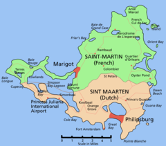
Granica francusko-holenderska
 | |
| Państwa graniczące | |
|---|---|
| Okres istnienia | od 1648 |
| W obecnym przebiegu | |
| Długość | 10 km |
Granica francusko-holenderska − granica międzypaństwowa, ciągnąca się na długości 10 km na położonej na Morzu Karaibskim wyspie Sint Maarten/Saint-Martin. Oba państwa nie graniczą z sobą na kontynencie europejskim, jest to zatem jedyna granica lądowa dzieląca terytoria francuskie i holenderskie.
Granica przebiega ze wschodu na zachód, od zatoki Baie Cupecoy przez Grand Etang de Simsonbaai, Marigot Hill (307 m n.p.m.) do Étang aux Huître (Oyster Pond) − dzieląc wyspę na północną część francuską i południową holenderską.
Wyspa została oficjalnie podzielona 23 marca 1648 roku.
Media użyte na tej stronie
Autor: Pedro A. Gracia Fajardo, escudo de Manual de Imagen Institucional de la Administración General del Estado, Licencja: CC0
Flaga Hiszpanii
House colours of the House of Habsburg
Flag of the Ottoman Empire (c. 1750s).[1]
A variety of Ottoman naval flags with crescents are recorded in Western sources during the 18th century.
Flaggen aller seefahrenden Nationen shows several Turkish naval flags with three crescents (heraldic decrescents, horns pointing away from the hoist as in the later Ottoman flag)


