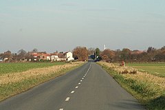
Great Heck
| ||
(c) Gordon Kneale Brooke, CC BY-SA 2.0 | ||
| Państwo | ||
|---|---|---|
| Kraj | ||
| Hrabstwo | North Yorkshire | |
| Dystrykt | Selby | |
Położenie na mapie North Yorkshire Contains Ordnance Survey data © Crown copyright and database right, CC BY-SA 3.0 | ||
Położenie na mapie Wielkiej Brytanii (c) Karte: NordNordWest, Lizenz: Creative Commons by-sa-3.0 de | ||
| Portal | ||
Great Heck – wieś w Anglii, w hrabstwie North Yorkshire, w dystrykcie Selby. Leży 31 km na południe od miasta York i 251 km na północ od Londynu[1].
Przypisy
- ↑ Great Heck na mapie (ang.). getamap.ordnancesurvey.co.uk. [dostęp 2010-10-06].
Media użyte na tej stronie
(c) Karte: NordNordWest, Lizenz: Creative Commons by-sa-3.0 de
Location map of the United Kingdom
Flag of England. Saint George's cross (a red cross on a white background), used as the Flag of England, the Italian city of Genoa and various other places.
(c) Gordon Kneale Brooke, CC BY-SA 2.0
Great Heck, Heck Lane. In the early 1800s there was a horse drawn railway down the right hand side of the road, it was used to transport stone from Wentbridge stone quarries to Heck canal basin, and then to different parts of the country. The rails were wooden. The white flagpole can be seen in the distance, that is Heck Basin. It is now Heck Boating Club
Contains Ordnance Survey data © Crown copyright and database right, CC BY-SA 3.0
Map of North Yorkshire, UK with the following information shown:
- Administrative borders
- Coastline, lakes and rivers
- Roads and railways
- Urban areas
Equirectangular map projection on WGS 84 datum, with N/S stretched 170%
Geographic limits:
- West: 2.60W
- East: 0.10W
- North: 54.67N
- South: 53.60N


