Great Yarmouth (borough)
| dystrykt niemetropolitalny | |
 Great Yarmouth | |
| Państwo | |
|---|---|
| Kraj | |
| Region | East of England |
| Hrabstwo | Norfolk |
| Siedziba | Great Yarmouth |
| Powierzchnia | 174 km² |
| Populacja (2011) • liczba ludności | 97 277 |
| • gęstość | 560 os./km² |
Położenie na mapie Norfolk | |
| Strona internetowa | |
| Portal | |
Great Yarmouth – dystrykt w hrabstwie Norfolk w Anglii. W 2011 roku dystrykt liczył 97 277 mieszkańców[1].
Miasta
Inne miejscowości
Ashby with Oby, Belton, Belton with Browston, Bradwell, Burgh Castle, Caister-on-Sea, Clippesby, Filby, Fleggburgh, Fritton and St Olaves, Hemsby, Hopton on Sea, Martham, Mautby, Ormesby St Margaret with Scratby, Ormesby St Michael, Repps with Bastwick, Rollesby, St Olaves, Somerton, Stokesby with Herringby, Thurne, West Caister, Winterton-on-Sea.
Przypisy
- ↑ Area: Great Yarmouth (Local Authority) (ang.). Neighbourhood Statistics (ONS). [dostęp 2016-04-21]. [zarchiwizowane z tego adresu (2016-09-28)].
Media użyte na tej stronie
Flag of England. Saint George's cross (a red cross on a white background), used as the Flag of England, the Italian city of Genoa and various other places.
Autor:
- Norfolk_UK_district_map_(blank).svg: Nilfanion, created using Ordnance Survey data
- derivative work: Renly (talk)
Map of Norfolk, with Great Yarmouth highlighted.
Autor: Moldovia, Licencja: CC BY-SA 3.0
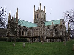
St Nicholas' parish church, Great Yarmouth, Norfolk


