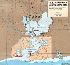
Guantánamo (zatoka)
 | |
| Państwo | |
|---|---|
| Lokalizacja | |
| Miejscowości nadbrzeżne | |
 | |
Guantánamo (ang. Guantánamo Bay, hiszp. Bahía de Guantánamo) – zatoka w prowincji Guantánamo na południowym wschodzie Kuby. Część zatoki znajduje się od 1903 roku pod administracją USA (Baza wojskowa Guantanamo), pomimo że rząd kubański twierdzi, iż teren jest okupowany przez USA, argumentując swoje stanowisko tym, że umowa zawarta w 1903 roku między Kubą a USA została zawarta niezgodnie z prawem[1].
Nazwę zatoce nadali Tainowie, Krzysztof Kolumb nazwał ją Puerto Grande.
Przypisy
- ↑ Breuer 1998 ↓, s. 140.
Bibliografia
- William B. Breuer: Vendetta! Castro i bracia Kennedy. Wyd. 1. Warszawa: Wydawnictwo Magnum, 1998. ISBN 83-85852-35-2.Sprawdź autora:1.
Media użyte na tej stronie
The flag of Navassa Island is simply the United States flag. It does not have a "local" flag or "unofficial" flag; it is an uninhabited island. The version with a profile view was based on Flags of the World and as a fictional design has no status warranting a place on any Wiki. It was made up by a random person with no connection to the island, it has never flown on the island, and it has never received any sort of recognition or validation by any authority. The person quoted on that page has no authority to bestow a flag, "unofficial" or otherwise, on the island.
Autor: Lithiumpilz, Licencja: CC BY-SA 4.0
Blue Sky near Guantanamo Bay in November 2016
CIA Government map of Guantanamo Bay Naval Base
Autor: Urutseg, Licencja: CC0
Cuba physical map, parameters equal to File:Cuba location map.svg


