Gudja
 | |||||
| Państwo | |||||
|---|---|---|---|---|---|
| Kod ISO 3166-2 | MT-11[1] | ||||
| Burmistrz | John Mary Calleja[2] | ||||
| Powierzchnia | 2,2 km²[3] | ||||
| Populacja (2014) • liczba ludności |
| ||||
| • gęstość | 1362 os./km² | ||||
| Kod pocztowy | GDJ | ||||
Adres urzędu: 88, Raymond Caruana StreetGudja GDJ 1010 Malta[5] | |||||
Położenie na mapie Malty | |||||
| 35°50′54″N 14°30′09″E/35,848333 14,502500 | |||||
Gudja – jedna z jednostek administracyjnych na Malcie. Mieszka tutaj 2997 osób[4].
Turystyka
- Kaplica Panny Maryi
- Wieża Xlejli
- Palazzo Dorell, palladiański pałac z 1670 roku[6]
- Parish Church of the Assumption, kościół z 1656 roku[7]
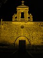
Kaplica Panny Maryi

Parish Church of the Assumption

Palazzo Dorell
Wieża Xlejli
Sport
W miejscowości funkcjonuje klub piłkarski Gudja United F.C. Powstał w 1945 roku. Obecnie gra w Maltese First Division, drugiej w hierarchii ligowej.
Przypisy
- ↑ ISO 3166-2 MT - Międzynarodowa Organizacja Normalizacyjna, 2015
- ↑ Council Members - Local Councils.gov.mt
- ↑ Localities of Malta - statoids.com
- ↑ a b Estimated Population by Locality 31st March, 2014. gov.mt. (ang.).
- ↑ Our Contact Details - Local Councils.gov.mt
- ↑ Palazzo Dorell - National Inventory of the Cultural Property of the Maltese Islands
- ↑ Parish Church of the Assumption - National Inventory of the Cultural Property of the Maltese Islands
| wyspa Malta Rady lokalne |
|
|---|---|
| wyspa Malta Komitety administracyjne |
|
| wyspa Gozo Rady lokalne | |
| wyspa Gozo Komitety administracyjne |

Media użyte na tej stronie

Coat of arms of Malta.svg
Coat of arms of Malta.
Coat of arms of Malta.

Bir Miftuħ Chapel.jpg
Autor: NickGeorge1993, Licencja: CC BY-SA 3.0
The façade of the medieval chapel of St Mary of Bir Miftuħ.
Autor: NickGeorge1993, Licencja: CC BY-SA 3.0
The façade of the medieval chapel of St Mary of Bir Miftuħ.


Gudja in Malta.svg
Autor: TUBS
 ,
Licencja: CC BY-SA 3.0
,
Licencja: CC BY-SA 3.0
Location of local council XY (see filename) in Malta
Autor: TUBS
Location of local council XY (see filename) in Malta

Parish Church of the Assumption.jpg
Autor: Continentaleurope, Licencja: CC BY-SA 4.0
This media is about Maltese cultural property with inventory number 01835.
Autor: Continentaleurope, Licencja: CC BY-SA 4.0
This media is about Maltese cultural property with inventory number 01835.
