Guiers
| ||
 | ||
| Kontynent | Europa | |
| Państwo | ||
| Rzeka | ||
| Długość | 50[1] km | |
| Powierzchnia zlewni | 609 km² | |
| Źródło | ||
| Miejsce | Saint-Pierre-de-Chartreuse | |
| Wysokość | 1 415 m n.p.m. | |
| Ujście | ||
| Recypient | Rodan | |
| Miejsce | Saint-Genix-sur-Guiers | |
| Wysokość | 212 m n.p.m. | |
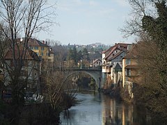
Guiers – rzeka we Francji, przepływająca przez teren departamentu Isère, o długości 50 km. Stanowi dopływ rzeki Rodan.
Zobacz też
Przypisy
- ↑ Marque w bazie services.sandre.eaufrance.fr (fr.). [dostęp 2013-11-20].
Media użyte na tej stronie
Autor:

|
This illustration was made by louis-garden
Please credit this : louis-garden An email to More pictures (not free) at My Photos Site |
Le pont sur le Guiers, entre les départements français de l'Isère (à gauche) et de la Savoie (à droite).

