Guildford
 (c) Colin Smith, CC BY-SA 2.0 | |
| Państwo | |
|---|---|
| Kraj | |
| Region | |
| Hrabstwo | |
| Dystrykt | |
| Populacja (2001) • liczba ludności |
|
| Nr kierunkowy | 01483 |
| Kod pocztowy | GU1-4 |
Położenie na mapie Surrey  Contains Ordnance Survey data © Crown copyright and database right, CC BY-SA 3.0 | |
Położenie na mapie Wielkiej Brytanii  (c) Karte: NordNordWest, Lizenz: Creative Commons by-sa-3.0 de | |
Położenie na mapie Anglii  | |
| Strona internetowa | |
| Portal | |
Guildford – miasto w południowo-wschodniej Anglii, w hrabstwie Surrey, w dystrykcie (borough) Guildford, położone na południowy zachód od Londynu, nad rzeką Wey (prawy dopływ Tamizy). W 2001 roku miasto liczyło 69 400 mieszkańców[1]. W mieście znajduje się uniwersytet (University of Surrey). Guildford jest wspomniana w Domesday Book (1086) jako Geldeford/Gildeford[2]. W mieście rozwinęły się przemysły: metalowy, samochodowy, włókienniczy oraz chemiczny[3].
Galeria

W latach II wojny światowej
 (c) Ben Brooksbank, CC BY-SA 2.0
Stacja kolejowa
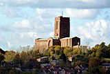 (c) Guildford Cathedral by Robert Ashby, CC BY-SA 2.0
Katedra anglikańska
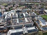
Uniwersytet
Przypisy
- ↑ KS01 Usual resident population: Census 2001, Key Statistics for urban areas (ang.). Office for National Statistics. [dostęp 2016-04-14]. [zarchiwizowane z tego adresu (2004-07-23)].
- ↑ Surrey (ang.). The Domesday Book online. [dostęp 2016-04-14].
- ↑ Guildford, [w:] Encyklopedia PWN [online] [dostęp 2021-07-05].
Media użyte na tej stronie
United Kingdom adm location map.svg
(c) Karte: NordNordWest, Lizenz: Creative Commons by-sa-3.0 de
Location map of the United Kingdom
(c) Karte: NordNordWest, Lizenz: Creative Commons by-sa-3.0 de
Location map of the United Kingdom


Flag of England.svg
Flag of England. Saint George's cross (a red cross on a white background), used as the Flag of England, the Italian city of Genoa and various other places.
Flag of England. Saint George's cross (a red cross on a white background), used as the Flag of England, the Italian city of Genoa and various other places.

Along Spine Road, University of Surrey.jpg
Autor: Tim Sheerman-Chase, Licencja: CC BY 2.0
Along Spine Road, University of Surrey
Autor: Tim Sheerman-Chase, Licencja: CC BY 2.0
Along Spine Road, University of Surrey
Central Guildford - geograph.org.uk - 856775.jpg
(c) Colin Smith, CC BY-SA 2.0
Central Guildford Closely-built offices and shops in the middle of the borough as seen from Guildown, at the top of The Mount. Most obvious are the new blocks of Bridge House and others between the railway station and the Friary Shopping Centre. Beyond the roofs is Stoke Park.

Guildford Cathedral - geograph.org.uk - 3221164.jpg
(c) Guildford Cathedral by Robert Ashby, CC BY-SA 2.0
Guildford Cathedral
(c) Guildford Cathedral by Robert Ashby, CC BY-SA 2.0
Guildford Cathedral
Surrey UK location map.svg
Contains Ordnance Survey data © Crown copyright and database right, CC BY-SA 3.0
Contains Ordnance Survey data © Crown copyright and database right, CC BY-SA 3.0
Map of Surrey, UK with the following information shown:
- Administrative borders
- Coastline, lakes and rivers
- Roads and railways
- Urban areas
Equirectangular map projection on WGS 84 datum, with N/S stretched 160%
Geographic limits:
- West: 0.87W
- East: 0.08E
- North: 51.50N
- South: 51.05N

Guildford station, 1992 geograph-3585331-by-Ben-Brooksbank.jpg
(c) Ben Brooksbank, CC BY-SA 2.0
Guildford station, 1992.
View northward on Platform 4, with an Up main-line EMU at Platform 5, not long after the station had been substantially rebuilt and modernised in 1990: ex-LSWR Waterloo - Woking - Portsmouth main line (also via Cobham from Surbiton), junction of ex-SE&CR Redhill - Reading line and of ex-LB&SCR branch to Horsham. The tower of Guildford Cathedral is in the left background.

Guildford- Everyday Life in Wartime Guildford, Surrey, England, UK, 1945 D25198.jpg
Guildford- Everyday Life in Wartime Guildford, Surrey, England, UK, 1945
A busy scene showing men and women going about their daily business at the junction of High Street and a Market Street in Guildford, Surrey. Clearly visible on the corner is 'The Bull's Head' public house, selling 'Amey's Celebrated Petersfield Fine Ales and Stout'. The photograph is taken looking down Market Street towards North Street.